|
|
|||||||||||||||||
| Point ID: 8141 | Downloads | Plots | Site Data | Code: 7196 |
|
|
|||||||||||||||||
| Download | |
|---|---|
| Site Descriptor Information | Site Time Series Data |
| Link to all available data | |
|
|
| View: | Statistics | Time Series |
| Units: | mm |
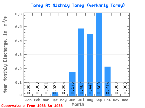
| Statistic | Jan | Feb | Mar | Apr | May | Jun | Jul | Aug | Sep | Oct | Nov | Dec | Annual |
|---|---|---|---|---|---|---|---|---|---|---|---|---|---|
| Mean | 0.00 | 0.00 | 0.00 | 0.03 | 0.01 | 0.17 | 0.49 | 0.45 | 0.60 | 0.21 | 0.00 | 0.00 | 0.15 |
| Standard Deviation | 0.00 | 0.00 | 0.00 | 0.06 | 0.01 | 0.22 | 0.55 | 0.11 | 0.31 | 0.14 | 0.00 | 0.00 | 0.08 |
| Min | 0.00 | 0.00 | 0.00 | 0.00 | 0.00 | 0.00 | 0.00 | 0.30 | 0.36 | 0.10 | 0.00 | 0.00 | 0.08 |
| Max | 0.00 | 0.00 | 0.00 | 0.12 | 0.02 | 0.47 | 1.09 | 0.54 | 1.00 | 0.38 | 0.00 | 0.00 | 0.23 |
| Coefficient of Variation | 2.00 | 2.00 | 1.73 | 1.24 | 1.12 | 0.25 | 0.51 | 0.65 | 1.73 | 0.50 |
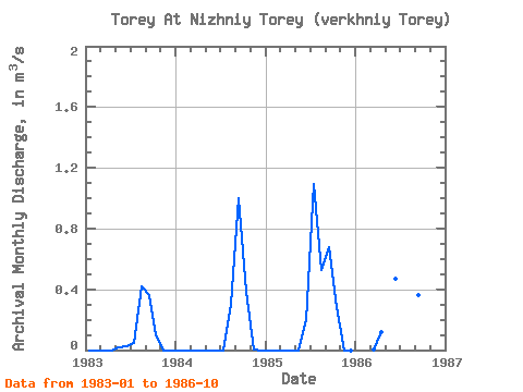
| Year | Jan | Feb | Mar | Apr | May | Jun | Jul | Aug | Sep | Oct | Nov | Dec | Annual | 1983 | 0.00 | 0.00 | 0.00 | 0.00 | 0.02 | 0.03 | 0.05 | 0.42 | 0.36 | 0.10 | 0.00 | 0.00 | 0.08 | 1984 | 0.00 | 0.00 | 0.00 | 0.00 | 0.00 | 0.00 | 0.00 | 0.30 | 1.00 | 0.38 | 0.00 | 0.00 | 0.14 | 1985 | 0.00 | 0.00 | 0.00 | 0.00 | 0.00 | 0.20 | 1.09 | 0.53 | 0.68 | 0.28 | 0.00 | 0.00 | 0.23 | 1986 | 0.00 | 0.12 | 0.47 | 0.81 | 0.54 | 0.36 | 0.10 |
|---|
 Return to R-Arctic Net Home Page