|
|
|||||||||||||||||
| Point ID: 8141 | Downloads | Plots | Site Data | Code: 7196 |
|
|
|||||||||||||||||
| Download | |
|---|---|
| Site Descriptor Information | Site Time Series Data |
| Link to all available data | |
|
|
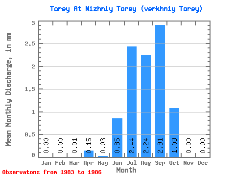
| View: | Statistics | Time Series |
| Units: | m3/s |
| Statistic | Jan | Feb | Mar | Apr | May | Jun | Jul | Aug | Sep | Oct | Nov | Dec | Annual |
|---|---|---|---|---|---|---|---|---|---|---|---|---|---|
| Mean | 0.00 | 0.00 | 0.00 | 0.14 | 0.03 | 0.84 | 2.44 | 2.24 | 2.91 | 1.08 | 0.00 | 0.00 | 8.90 |
| Standard Deviation | 0.00 | 0.00 | 0.01 | 0.29 | 0.05 | 1.05 | 2.74 | 0.56 | 1.48 | 0.69 | 0.00 | 0.00 | 4.48 |
| Min | 0.00 | 0.00 | 0.00 | 0.00 | 0.00 | 0.00 | 0.00 | 1.50 | 1.74 | 0.50 | 0.00 | 0.00 | 4.78 |
| Max | 0.00 | 0.00 | 0.01 | 0.58 | 0.09 | 2.28 | 5.46 | 2.70 | 4.84 | 1.90 | 0.01 | 0.00 | 13.67 |
| Coefficient of Variation | 2.00 | 2.00 | 1.73 | 1.24 | 1.12 | 0.25 | 0.51 | 0.65 | 1.73 | 0.50 |
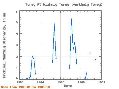
| Year | Jan | Feb | Mar | Apr | May | Jun | Jul | Aug | Sep | Oct | Nov | Dec | Annual | 1983 | 0.00 | 0.00 | 0.00 | 0.00 | 0.09 | 0.14 | 0.23 | 2.10 | 1.74 | 0.50 | 0.00 | 0.00 | 4.78 | 1984 | 0.00 | 0.00 | 0.00 | 0.00 | 0.00 | 0.00 | 0.00 | 1.50 | 4.84 | 1.90 | 0.01 | 0.00 | 8.26 | 1985 | 0.00 | 0.00 | 0.00 | 0.00 | 0.00 | 0.97 | 5.46 | 2.65 | 3.29 | 1.40 | 0.00 | 0.00 | 13.67 | 1986 | 0.01 | 0.58 | 2.28 | 4.05 | 2.70 | 1.74 | 0.50 |
|---|
 Return to R-Arctic Net Home Page