|
|
|||||||||||||||||
| Point ID: 8124 | Downloads | Plots | Site Data | Code: 1607 |
|
|
|||||||||||||||||
| Download | |
|---|---|
| Site Descriptor Information | Site Time Series Data |
| Link to all available data | |
|
|
| View: | Statistics | Time Series |
| Units: | mm |
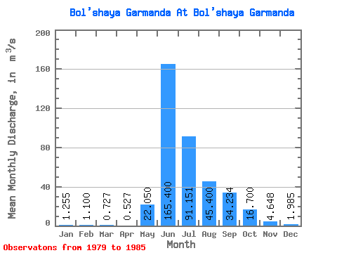
| Statistic | Jan | Feb | Mar | Apr | May | Jun | Jul | Aug | Sep | Oct | Nov | Dec | Annual |
|---|---|---|---|---|---|---|---|---|---|---|---|---|---|
| Mean | 1.25 | 1.10 | 0.73 | 0.53 | 22.05 | 165.40 | 91.15 | 45.40 | 34.23 | 16.70 | 4.65 | 1.98 | 32.25 |
| Standard Deviation | 0.93 | 0.61 | 0.28 | 0.15 | 15.35 | 119.64 | 101.61 | 3.40 | 11.32 | 0.70 | 1.90 | 0.63 | 18.15 |
| Min | 0.60 | 0.45 | 0.41 | 0.35 | 11.20 | 80.80 | 19.30 | 43.00 | 27.30 | 16.20 | 2.70 | 1.29 | 19.42 |
| Max | 1.91 | 1.66 | 0.90 | 0.63 | 32.90 | 250.00 | 163.00 | 47.80 | 47.30 | 17.50 | 7.19 | 2.77 | 45.09 |
| Coefficient of Variation | 0.74 | 0.56 | 0.38 | 0.29 | 0.70 | 0.72 | 1.11 | 0.07 | 0.33 | 0.04 | 0.41 | 0.32 | 0.56 |
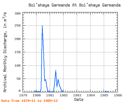
| Year | Jan | Feb | Mar | Apr | May | Jun | Jul | Aug | Sep | Oct | Nov | Dec | Annual | 1979 | 3.94 | 2.77 | 1980 | 1.91 | 1.66 | 0.90 | 0.60 | 11.20 | 250.00 | 163.00 | 43.00 | 47.30 | 17.50 | 2.70 | 1.29 | 45.09 | 1981 | 0.60 | 0.45 | 0.41 | 0.35 | 32.90 | 80.80 | 19.30 | 47.80 | 27.30 | 16.20 | 4.76 | 2.16 | 19.42 | 1985 | 1.19 | 0.87 | 0.63 | 28.10 | 16.40 | 7.19 | 1.72 |
|---|
 Return to R-Arctic Net Home Page