|
|
|||||||||||||||||
| Point ID: 8124 | Downloads | Plots | Site Data | Code: 1607 |
|
|
|||||||||||||||||
| Download | |
|---|---|
| Site Descriptor Information | Site Time Series Data |
| Link to all available data | |
|
|
| View: | Statistics | Time Series |
| Units: | m3/s |
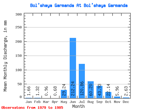
| Statistic | Jan | Feb | Mar | Apr | May | Jun | Jul | Aug | Sep | Oct | Nov | Dec | Annual |
|---|---|---|---|---|---|---|---|---|---|---|---|---|---|
| Mean | 1.66 | 1.33 | 0.96 | 0.68 | 29.23 | 212.24 | 120.84 | 60.19 | 43.93 | 22.14 | 5.96 | 2.63 | 503.93 |
| Standard Deviation | 1.23 | 0.74 | 0.36 | 0.20 | 20.34 | 153.52 | 134.71 | 4.50 | 14.53 | 0.93 | 2.43 | 0.84 | 283.58 |
| Min | 0.80 | 0.54 | 0.54 | 0.45 | 14.85 | 103.68 | 25.59 | 57.01 | 35.03 | 21.48 | 3.46 | 1.71 | 303.41 |
| Max | 2.53 | 2.00 | 1.19 | 0.81 | 43.62 | 320.79 | 216.10 | 63.37 | 60.69 | 23.20 | 9.23 | 3.67 | 704.45 |
| Coefficient of Variation | 0.74 | 0.56 | 0.38 | 0.29 | 0.70 | 0.72 | 1.11 | 0.07 | 0.33 | 0.04 | 0.41 | 0.32 | 0.56 |
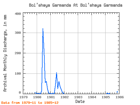
| Year | Jan | Feb | Mar | Apr | May | Jun | Jul | Aug | Sep | Oct | Nov | Dec | Annual | 1979 | 5.06 | 3.67 | 1980 | 2.53 | 2.00 | 1.19 | 0.77 | 14.85 | 320.79 | 216.10 | 57.01 | 60.69 | 23.20 | 3.46 | 1.71 | 704.45 | 1981 | 0.80 | 0.54 | 0.54 | 0.45 | 43.62 | 103.68 | 25.59 | 63.37 | 35.03 | 21.48 | 6.11 | 2.86 | 303.41 | 1985 | 1.44 | 1.15 | 0.81 | 36.06 | 21.74 | 9.23 | 2.28 |
|---|
 Return to R-Arctic Net Home Page