|
|
|||||||||||||||||
| Point ID: 8119 | Downloads | Plots | Site Data | Code: 1599 |
|
|
|||||||||||||||||
| Download | |
|---|---|
| Site Descriptor Information | Site Time Series Data |
| Link to all available data | |
|
|
| View: | Statistics | Time Series |
| Units: | mm |
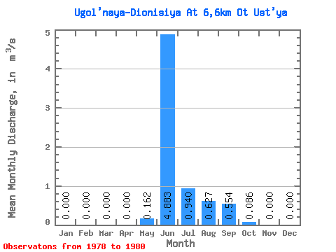
| Statistic | Jan | Feb | Mar | Apr | May | Jun | Jul | Aug | Sep | Oct | Nov | Dec | Annual |
|---|---|---|---|---|---|---|---|---|---|---|---|---|---|
| Mean | 0.00 | 0.00 | 0.00 | 0.00 | 0.16 | 4.88 | 0.94 | 0.63 | 0.55 | 0.09 | 0.00 | 0.00 | 0.60 |
| Standard Deviation | 0.00 | 0.00 | 0.00 | 0.00 | 0.17 | 0.93 | 0.50 | 0.49 | 0.45 | 0.07 | 0.00 | 0.00 | 0.15 |
| Min | 0.00 | 0.00 | 0.00 | 0.00 | 0.03 | 4.24 | 0.39 | 0.27 | 0.04 | 0.01 | 0.00 | 0.00 | 0.47 |
| Max | 0.00 | 0.00 | 0.00 | 0.00 | 0.35 | 5.95 | 1.37 | 1.19 | 0.87 | 0.15 | 0.00 | 0.00 | 0.76 |
| Coefficient of Variation | 1.04 | 0.19 | 0.53 | 0.79 | 0.81 | 0.80 | 0.24 |
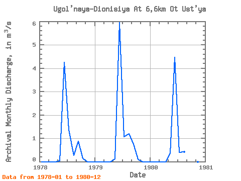
| Year | Jan | Feb | Mar | Apr | May | Jun | Jul | Aug | Sep | Oct | Nov | Dec | Annual | 1978 | 0.00 | 0.00 | 0.00 | 0.00 | 0.03 | 4.24 | 1.37 | 0.27 | 0.87 | 0.15 | 0.00 | 0.00 | 0.58 | 1979 | 0.00 | 0.00 | 0.00 | 0.00 | 0.11 | 5.95 | 1.06 | 1.19 | 0.75 | 0.10 | 0.00 | 0.00 | 0.76 | 1980 | 0.00 | 0.00 | 0.00 | 0.00 | 0.35 | 4.46 | 0.39 | 0.42 | 0.04 | 0.01 | 0.00 | 0.00 | 0.47 |
|---|
 Return to R-Arctic Net Home Page