|
|
|||||||||||||||||
| Point ID: 8114 | Downloads | Plots | Site Data | Code: 1583 |
|
|
|||||||||||||||||
| Download | |
|---|---|
| Site Descriptor Information | Site Time Series Data |
| Link to all available data | |
|
|
| View: | Statistics | Time Series |
| Units: | mm |
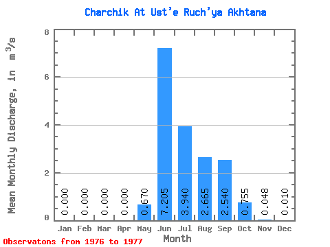
| Statistic | Jan | Feb | Mar | Apr | May | Jun | Jul | Aug | Sep | Oct | Nov | Dec | Annual |
|---|---|---|---|---|---|---|---|---|---|---|---|---|---|
| Mean | 0.00 | 0.00 | 0.00 | 0.00 | 0.67 | 7.21 | 3.94 | 2.67 | 2.54 | 0.76 | 0.05 | 0.01 | 1.49 |
| Standard Deviation | 0.00 | 0.00 | 0.00 | 0.00 | 0.71 | 1.83 | 1.56 | 1.73 | 1.71 | 0.59 | 0.05 | 0.01 | 0.67 |
| Min | 0.00 | 0.00 | 0.00 | 0.00 | 0.17 | 5.91 | 2.84 | 1.44 | 1.33 | 0.34 | 0.01 | 0.00 | 1.01 |
| Max | 0.00 | 0.00 | 0.00 | 0.00 | 1.17 | 8.50 | 5.04 | 3.89 | 3.75 | 1.17 | 0.09 | 0.02 | 1.96 |
| Coefficient of Variation | 1.05 | 0.25 | 0.40 | 0.65 | 0.67 | 0.78 | 1.09 | 1.41 | 0.45 |
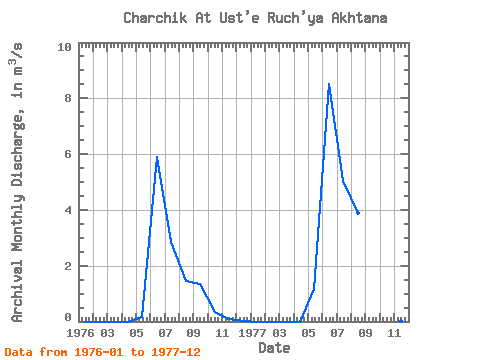
| Year | Jan | Feb | Mar | Apr | May | Jun | Jul | Aug | Sep | Oct | Nov | Dec | Annual | 1976 | 0.00 | 0.00 | 0.00 | 0.00 | 0.17 | 5.91 | 2.84 | 1.44 | 1.33 | 0.34 | 0.09 | 0.02 | 1.01 | 1977 | 0.00 | 0.00 | 0.00 | 0.00 | 1.17 | 8.50 | 5.04 | 3.89 | 3.75 | 1.17 | 0.01 | 0.00 | 1.96 |
|---|
 Return to R-Arctic Net Home Page