|
|
|||||||||||||||||
| Point ID: 8114 | Downloads | Plots | Site Data | Code: 1583 |
|
|
|||||||||||||||||
| Download | |
|---|---|
| Site Descriptor Information | Site Time Series Data |
| Link to all available data | |
|
|
| View: | Statistics | Time Series |
| Units: | m3/s |
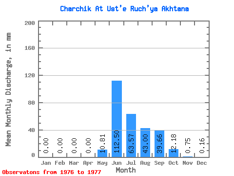
| Statistic | Jan | Feb | Mar | Apr | May | Jun | Jul | Aug | Sep | Oct | Nov | Dec | Annual |
|---|---|---|---|---|---|---|---|---|---|---|---|---|---|
| Mean | 0.00 | 0.00 | 0.00 | 0.00 | 10.81 | 112.50 | 63.56 | 42.99 | 39.66 | 12.18 | 0.75 | 0.16 | 282.54 |
| Standard Deviation | 0.00 | 0.00 | 0.00 | 0.00 | 11.41 | 28.60 | 25.10 | 27.95 | 26.72 | 9.47 | 0.82 | 0.23 | 127.67 |
| Min | 0.00 | 0.00 | 0.00 | 0.00 | 2.74 | 92.28 | 45.82 | 23.23 | 20.77 | 5.49 | 0.17 | 0.00 | 192.26 |
| Max | 0.00 | 0.00 | 0.00 | 0.00 | 18.88 | 132.72 | 81.31 | 62.76 | 58.55 | 18.88 | 1.33 | 0.32 | 372.81 |
| Coefficient of Variation | 1.05 | 0.25 | 0.40 | 0.65 | 0.67 | 0.78 | 1.09 | 1.41 | 0.45 |
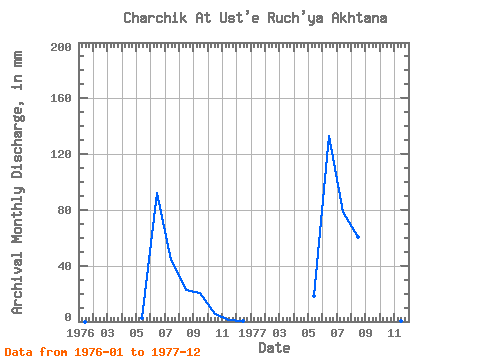
| Year | Jan | Feb | Mar | Apr | May | Jun | Jul | Aug | Sep | Oct | Nov | Dec | Annual | 1976 | 0.00 | 0.00 | 0.00 | 0.00 | 2.74 | 92.28 | 45.82 | 23.23 | 20.77 | 5.49 | 1.33 | 0.32 | 192.26 | 1977 | 0.00 | 0.00 | 0.00 | 0.00 | 18.88 | 132.72 | 81.31 | 62.76 | 58.55 | 18.88 | 0.17 | 0.00 | 372.81 |
|---|
 Return to R-Arctic Net Home Page