|
|
|||||||||||||||||
| Point ID: 8089 | Downloads | Plots | Site Data | Code: 1514 |
|
|
|||||||||||||||||
| Download | |
|---|---|
| Site Descriptor Information | Site Time Series Data |
| Link to all available data | |
|
|
| View: | Statistics | Time Series |
| Units: | mm |
| Statistic | Jan | Feb | Mar | Apr | May | Jun | Jul | Aug | Sep | Oct | Nov | Dec | Annual |
|---|---|---|---|---|---|---|---|---|---|---|---|---|---|
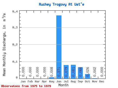
| Mean | 0.00 | 0.00 | 0.00 | 0.00 | 0.01 | 0.37 | 0.08 | 0.08 | 0.07 | 0.03 | 0.00 | 0.00 | 0.05 |
| Standard Deviation | 0.00 | 0.00 | 0.00 | 0.00 | 0.01 | 0.14 | 0.12 | 0.06 | 0.03 | 0.01 | 0.00 | 0.00 | 0.02 |
| Min | 0.00 | 0.00 | 0.00 | 0.00 | 0.00 | 0.19 | 0.00 | 0.00 | 0.04 | 0.02 | 0.00 | 0.00 | 0.04 |
| Max | 0.00 | 0.00 | 0.00 | 0.00 | 0.01 | 0.52 | 0.25 | 0.15 | 0.12 | 0.05 | 0.01 | 0.00 | 0.08 |
| Coefficient of Variation | 0.90 | 0.37 | 1.47 | 0.78 | 0.45 | 0.56 | 2.21 | 2.24 | 0.40 |
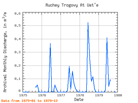
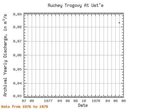
| Year | Jan | Feb | Mar | Apr | May | Jun | Jul | Aug | Sep | Oct | Nov | Dec | Annual | 1975 | 0.00 | 0.00 | 0.00 | 0.00 | 0.04 | 0.05 | 0.00 | 0.00 | 1976 | 0.00 | 0.00 | 0.00 | 0.00 | 0.00 | 0.36 | 0.00 | 0.00 | 0.05 | 0.02 | 0.00 | 0.00 | 0.04 | 1977 | 0.00 | 0.00 | 0.00 | 0.00 | 0.01 | 0.19 | 0.02 | 0.15 | 0.07 | 0.02 | 0.01 | 0.00 | 0.04 | 1978 | 0.00 | 0.00 | 0.00 | 0.00 | 0.00 | 0.52 | 0.25 | 0.08 | 0.12 | 0.02 | 0.00 | 0.00 | 0.08 | 1979 | 0.00 | 0.00 | 0.00 | 0.00 | 0.01 | 0.41 | 0.04 | 0.09 | 0.06 | 0.02 | 0.00 | 0.00 | 0.05 |
|---|
 Return to R-Arctic Net Home Page