|
|
|||||||||||||||||
| Point ID: 8089 | Downloads | Plots | Site Data | Code: 1514 |
|
|
|||||||||||||||||
| Download | |
|---|---|
| Site Descriptor Information | Site Time Series Data |
| Link to all available data | |
|
|
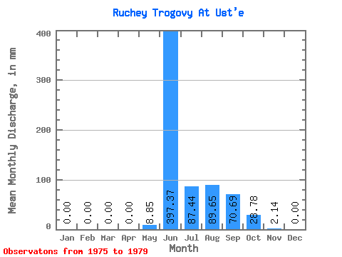
| View: | Statistics | Time Series |
| Units: | m3/s |
| Statistic | Jan | Feb | Mar | Apr | May | Jun | Jul | Aug | Sep | Oct | Nov | Dec | Annual |
|---|---|---|---|---|---|---|---|---|---|---|---|---|---|
| Mean | 0.00 | 0.00 | 0.00 | 0.00 | 8.36 | 397.76 | 87.70 | 90.16 | 70.59 | 28.97 | 1.96 | 0.01 | 689.57 |
| Standard Deviation | 0.00 | 0.00 | 0.00 | 0.00 | 7.51 | 146.41 | 128.60 | 70.05 | 31.91 | 16.20 | 4.34 | 0.04 | 276.52 |
| Min | 0.00 | 0.00 | 0.00 | 0.00 | 0.00 | 205.72 | 3.32 | 0.74 | 40.35 | 17.34 | 0.00 | 0.00 | 474.21 |
| Max | 0.00 | 0.00 | 0.00 | 0.00 | 16.68 | 558.75 | 278.87 | 171.60 | 124.32 | 57.54 | 9.71 | 0.08 | 1080.93 |
| Coefficient of Variation | 0.90 | 0.37 | 1.47 | 0.78 | 0.45 | 0.56 | 2.21 | 2.24 | 0.40 |
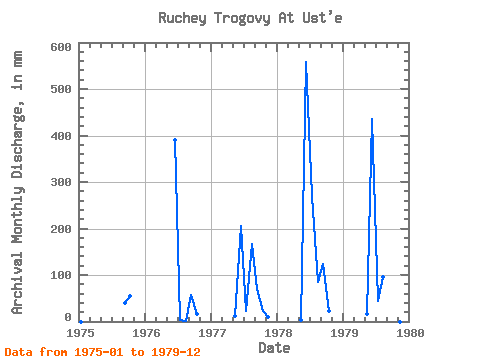
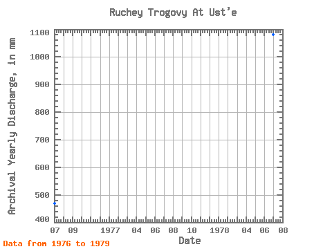
| Year | Jan | Feb | Mar | Apr | May | Jun | Jul | Aug | Sep | Oct | Nov | Dec | Annual | 1975 | 0.00 | 0.00 | 0.00 | 0.00 | 40.35 | 57.54 | 0.00 | 0.00 | 1976 | 0.00 | 0.00 | 0.00 | 0.00 | 0.00 | 390.59 | 3.32 | 0.74 | 56.41 | 17.34 | 0.00 | 0.00 | 474.21 | 1977 | 0.00 | 0.00 | 0.00 | 0.00 | 12.25 | 205.72 | 23.24 | 171.60 | 69.69 | 24.42 | 9.71 | 0.08 | 516.83 | 1978 | 0.00 | 0.00 | 0.00 | 0.00 | 4.50 | 558.75 | 278.87 | 88.61 | 124.32 | 23.32 | 0.00 | 0.00 | 1080.93 | 1979 | 0.00 | 0.00 | 0.00 | 0.00 | 16.68 | 436.00 | 45.37 | 99.67 | 62.20 | 22.21 | 0.07 | 0.00 | 686.29 |
|---|
 Return to R-Arctic Net Home Page