|
|
|||||||||||||||||
| Point ID: 8075 | Downloads | Plots | Site Data | Code: 1422 |
|
|
|||||||||||||||||
| Download | |
|---|---|
| Site Descriptor Information | Site Time Series Data |
| Link to all available data | |
|
|
| View: | Statistics | Time Series |
| Units: | mm |
| Statistic | Jan | Feb | Mar | Apr | May | Jun | Jul | Aug | Sep | Oct | Nov | Dec | Annual |
|---|---|---|---|---|---|---|---|---|---|---|---|---|---|
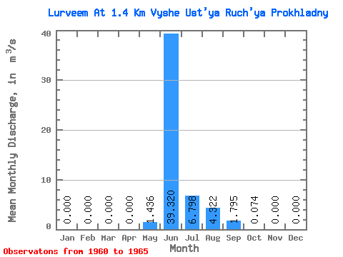
| Mean | 0.00 | 0.00 | 0.00 | 0.00 | 1.44 | 39.32 | 6.80 | 4.32 | 1.79 | 0.07 | 0.00 | 0.00 | 4.46 |
| Standard Deviation | 0.00 | 0.00 | 0.00 | 0.00 | 2.78 | 24.38 | 5.05 | 2.30 | 1.98 | 0.09 | 0.00 | 0.00 | 2.08 |
| Min | 0.00 | 0.00 | 0.00 | 0.00 | 0.00 | 17.30 | 3.34 | 1.83 | 0.46 | 0.00 | 0.00 | 0.00 | 2.61 |
| Max | 0.00 | 0.00 | 0.00 | 0.00 | 6.39 | 79.70 | 15.60 | 7.46 | 5.39 | 0.23 | 0.00 | 0.00 | 7.85 |
| Coefficient of Variation | 1.93 | 0.62 | 0.74 | 0.53 | 1.10 | 1.18 | 0.47 |
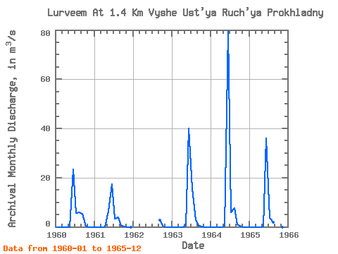
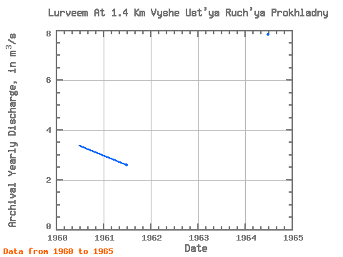
| Year | Jan | Feb | Mar | Apr | May | Jun | Jul | Aug | Sep | Oct | Nov | Dec | Annual | 1960 | 0.00 | 0.00 | 0.00 | 0.00 | 0.00 | 23.50 | 5.50 | 5.80 | 5.39 | 0.12 | 0.00 | 0.00 | 3.36 | 1961 | 0.00 | 0.00 | 0.00 | 0.00 | 6.39 | 17.30 | 3.34 | 3.80 | 0.46 | 0.02 | 0.00 | 0.00 | 2.61 | 1962 | 2.86 | 0.04 | 0.00 | 0.00 | 1963 | 0.00 | 0.00 | 0.00 | 0.00 | 0.51 | 40.00 | 15.60 | 2.72 | 0.48 | 0.23 | 0.00 | 0.00 | 4.96 | 1964 | 0.00 | 0.00 | 0.00 | 0.00 | 0.10 | 79.70 | 5.91 | 7.46 | 0.97 | 0.03 | 0.00 | 0.00 | 7.85 | 1965 | 0.00 | 0.00 | 0.00 | 0.00 | 0.18 | 36.10 | 3.64 | 1.83 | 0.61 | 0.00 | 0.00 | 0.00 | 3.53 |
|---|
 Return to R-Arctic Net Home Page