|
|
|||||||||||||||||
| Point ID: 8075 | Downloads | Plots | Site Data | Code: 1422 |
|
|
|||||||||||||||||
| Download | |
|---|---|
| Site Descriptor Information | Site Time Series Data |
| Link to all available data | |
|
|
| View: | Statistics | Time Series |
| Units: | m3/s |
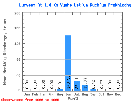
| Statistic | Jan | Feb | Mar | Apr | May | Jun | Jul | Aug | Sep | Oct | Nov | Dec | Annual |
|---|---|---|---|---|---|---|---|---|---|---|---|---|---|
| Mean | 0.00 | 0.00 | 0.00 | 0.00 | 5.30 | 140.58 | 25.11 | 15.96 | 6.42 | 0.27 | 0.00 | 0.00 | 194.22 |
| Standard Deviation | 0.00 | 0.00 | 0.00 | 0.00 | 10.25 | 87.14 | 18.64 | 8.48 | 7.09 | 0.32 | 0.00 | 0.00 | 90.33 |
| Min | 0.00 | 0.00 | 0.00 | 0.00 | 0.00 | 61.85 | 12.34 | 6.76 | 1.65 | 0.01 | 0.00 | 0.00 | 113.59 |
| Max | 0.00 | 0.00 | 0.00 | 0.00 | 23.60 | 284.94 | 57.62 | 27.56 | 19.27 | 0.85 | 0.00 | 0.00 | 341.59 |
| Coefficient of Variation | 1.93 | 0.62 | 0.74 | 0.53 | 1.10 | 1.18 | 0.47 |
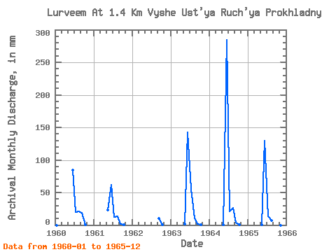
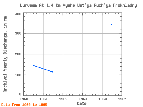
| Year | Jan | Feb | Mar | Apr | May | Jun | Jul | Aug | Sep | Oct | Nov | Dec | Annual | 1960 | 0.00 | 0.00 | 0.00 | 0.00 | 0.00 | 84.02 | 20.32 | 21.42 | 19.27 | 0.44 | 0.00 | 0.00 | 146.23 | 1961 | 0.00 | 0.00 | 0.00 | 0.00 | 23.60 | 61.85 | 12.34 | 14.04 | 1.65 | 0.09 | 0.00 | 0.00 | 113.59 | 1962 | 10.22 | 0.14 | 0.00 | 0.00 | 1963 | 0.00 | 0.00 | 0.00 | 0.00 | 1.88 | 143.01 | 57.62 | 10.05 | 1.72 | 0.85 | 0.00 | 0.00 | 215.99 | 1964 | 0.00 | 0.00 | 0.00 | 0.00 | 0.37 | 284.94 | 21.83 | 27.56 | 3.47 | 0.09 | 0.00 | 0.00 | 341.59 | 1965 | 0.00 | 0.00 | 0.00 | 0.00 | 0.67 | 129.06 | 13.45 | 6.76 | 2.18 | 0.01 | 0.00 | 0.00 | 153.68 |
|---|
 Return to R-Arctic Net Home Page