|
|
|||||||||||||||||
| Point ID: 8068 | Downloads | Plots | Site Data | Code: 1390 |
|
|
|||||||||||||||||
| Download | |
|---|---|
| Site Descriptor Information | Site Time Series Data |
| Link to all available data | |
|
|
| View: | Statistics | Time Series |
| Units: | mm |
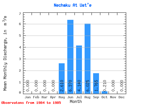
| Statistic | Jan | Feb | Mar | Apr | May | Jun | Jul | Aug | Sep | Oct | Nov | Dec | Annual |
|---|---|---|---|---|---|---|---|---|---|---|---|---|---|
| Mean | 0.00 | 0.00 | 0.00 | 0.00 | 2.61 | 6.37 | 4.14 | 6.03 | 1.77 | 0.21 | 0.00 | 0.00 | 1.76 |
| Standard Deviation | 0.00 | 0.00 | 0.00 | 0.00 | 0.30 | 3.11 | 1.63 | 1.27 | 0.01 | 0.11 | 0.00 | 0.00 | 0.20 |
| Min | 0.00 | 0.00 | 0.00 | 0.00 | 2.40 | 4.17 | 2.99 | 5.13 | 1.76 | 0.13 | 0.00 | 0.00 | 1.62 |
| Max | 0.00 | 0.00 | 0.00 | 0.00 | 2.82 | 8.57 | 5.29 | 6.92 | 1.77 | 0.29 | 0.00 | 0.00 | 1.90 |
| Coefficient of Variation | 0.11 | 0.49 | 0.39 | 0.21 | 0.00 | 0.54 | 0.11 |
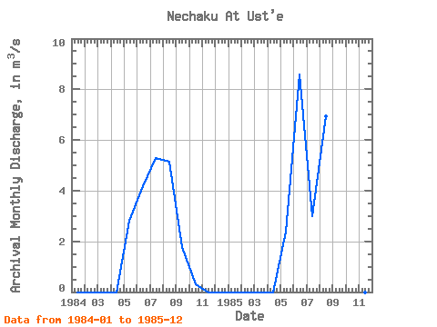
| Year | Jan | Feb | Mar | Apr | May | Jun | Jul | Aug | Sep | Oct | Nov | Dec | Annual | 1984 | 0.00 | 0.00 | 0.00 | 0.00 | 2.82 | 4.17 | 5.29 | 5.13 | 1.76 | 0.29 | 0.00 | 0.00 | 1.62 | 1985 | 0.00 | 0.00 | 0.00 | 0.00 | 2.40 | 8.57 | 2.99 | 6.92 | 1.77 | 0.13 | 0.00 | 0.00 | 1.90 |
|---|
 Return to R-Arctic Net Home Page