|
|
|||||||||||||||||
| Point ID: 8068 | Downloads | Plots | Site Data | Code: 1390 |
|
|
|||||||||||||||||
| Download | |
|---|---|
| Site Descriptor Information | Site Time Series Data |
| Link to all available data | |
|
|
| View: | Statistics | Time Series |
| Units: | m3/s |
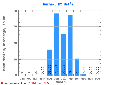
| Statistic | Jan | Feb | Mar | Apr | May | Jun | Jul | Aug | Sep | Oct | Nov | Dec | Annual |
|---|---|---|---|---|---|---|---|---|---|---|---|---|---|
| Mean | 0.00 | 0.00 | 0.00 | 0.00 | 32.06 | 75.74 | 50.86 | 74.01 | 20.99 | 2.58 | 0.00 | 0.00 | 254.80 |
| Standard Deviation | 0.00 | 0.00 | 0.00 | 0.00 | 3.65 | 36.99 | 19.98 | 15.55 | 0.08 | 1.39 | 0.00 | 0.00 | 28.32 |
| Min | 0.00 | 0.00 | 0.00 | 0.00 | 29.48 | 49.58 | 36.73 | 63.02 | 20.93 | 1.60 | 0.00 | 0.00 | 234.77 |
| Max | 0.00 | 0.00 | 0.00 | 0.00 | 34.64 | 101.90 | 64.98 | 85.01 | 21.05 | 3.56 | 0.00 | 0.00 | 274.82 |
| Coefficient of Variation | 0.11 | 0.49 | 0.39 | 0.21 | 0.00 | 0.54 | 0.11 |
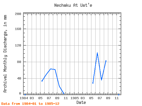
| Year | Jan | Feb | Mar | Apr | May | Jun | Jul | Aug | Sep | Oct | Nov | Dec | Annual | 1984 | 0.00 | 0.00 | 0.00 | 0.00 | 34.64 | 49.58 | 64.98 | 63.02 | 20.93 | 3.56 | 0.00 | 0.00 | 234.77 | 1985 | 0.00 | 0.00 | 0.00 | 0.00 | 29.48 | 101.90 | 36.73 | 85.01 | 21.05 | 1.60 | 0.00 | 0.00 | 274.82 |
|---|
 Return to R-Arctic Net Home Page