|
|
|||||||||||||||||
| Point ID: 8067 | Downloads | Plots | Site Data | Code: 1388 |
|
|
|||||||||||||||||
| Download | |
|---|---|
| Site Descriptor Information | Site Time Series Data |
| Link to all available data | |
|
|
| View: | Statistics | Time Series |
| Units: | mm |
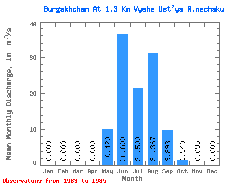
| Statistic | Jan | Feb | Mar | Apr | May | Jun | Jul | Aug | Sep | Oct | Nov | Dec | Annual |
|---|---|---|---|---|---|---|---|---|---|---|---|---|---|
| Mean | 0.00 | 0.00 | 0.00 | 0.00 | 10.12 | 36.60 | 21.50 | 31.37 | 9.89 | 1.54 | 0.10 | 0.00 | 9.26 |
| Standard Deviation | 0.00 | 0.00 | 0.00 | 0.00 | 3.46 | 14.58 | 11.41 | 4.03 | 1.82 | 0.38 | 0.11 | 0.00 | 1.81 |
| Min | 0.00 | 0.00 | 0.00 | 0.00 | 6.79 | 27.20 | 10.80 | 26.80 | 7.98 | 1.19 | 0.00 | 0.00 | 7.18 |
| Max | 0.00 | 0.00 | 0.00 | 0.00 | 13.70 | 53.40 | 33.50 | 34.40 | 11.60 | 1.94 | 0.22 | 0.00 | 10.51 |
| Coefficient of Variation | 0.34 | 0.40 | 0.53 | 0.13 | 0.18 | 0.24 | 1.19 | 0.20 |
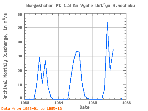
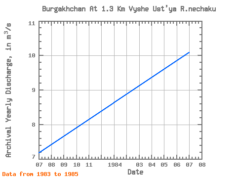
| Year | Jan | Feb | Mar | Apr | May | Jun | Jul | Aug | Sep | Oct | Nov | Dec | Annual | 1983 | 0.00 | 0.00 | 0.00 | 0.00 | 9.87 | 29.20 | 10.80 | 26.80 | 7.98 | 1.49 | 0.00 | 0.00 | 7.18 | 1984 | 0.00 | 0.00 | 0.00 | 0.00 | 13.70 | 27.20 | 33.50 | 32.90 | 11.60 | 1.94 | 0.22 | 0.00 | 10.09 | 1985 | 0.00 | 0.00 | 0.00 | 0.00 | 6.79 | 53.40 | 20.20 | 34.40 | 10.10 | 1.19 | 0.07 | 0.00 | 10.51 |
|---|
 Return to R-Arctic Net Home Page