|
|
|||||||||||||||||
| Point ID: 8067 | Downloads | Plots | Site Data | Code: 1388 |
|
|
|||||||||||||||||
| Download | |
|---|---|
| Site Descriptor Information | Site Time Series Data |
| Link to all available data | |
|
|
| View: | Statistics | Time Series |
| Units: | m3/s |
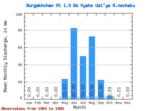
| Statistic | Jan | Feb | Mar | Apr | May | Jun | Jul | Aug | Sep | Oct | Nov | Dec | Annual |
|---|---|---|---|---|---|---|---|---|---|---|---|---|---|
| Mean | 0.00 | 0.00 | 0.00 | 0.00 | 23.57 | 82.49 | 50.07 | 73.04 | 22.30 | 3.59 | 0.21 | 0.00 | 254.12 |
| Standard Deviation | 0.00 | 0.00 | 0.00 | 0.00 | 8.06 | 32.87 | 26.56 | 9.37 | 4.10 | 0.88 | 0.26 | 0.00 | 49.80 |
| Min | 0.00 | 0.00 | 0.00 | 0.00 | 15.81 | 61.31 | 25.15 | 62.41 | 17.99 | 2.77 | 0.00 | 0.00 | 197.00 |
| Max | 0.00 | 0.00 | 0.00 | 0.00 | 31.90 | 120.36 | 78.01 | 80.11 | 26.14 | 4.52 | 0.50 | 0.00 | 288.49 |
| Coefficient of Variation | 0.34 | 0.40 | 0.53 | 0.13 | 0.18 | 0.24 | 1.19 | 0.20 |
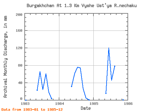
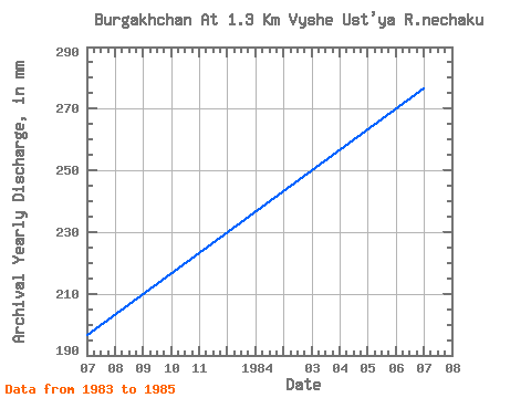
| Year | Jan | Feb | Mar | Apr | May | Jun | Jul | Aug | Sep | Oct | Nov | Dec | Annual | 1983 | 0.00 | 0.00 | 0.00 | 0.00 | 22.98 | 65.81 | 25.15 | 62.41 | 17.99 | 3.47 | 0.00 | 0.00 | 197.00 | 1984 | 0.00 | 0.00 | 0.00 | 0.00 | 31.90 | 61.31 | 78.01 | 76.61 | 26.14 | 4.52 | 0.50 | 0.00 | 276.86 | 1985 | 0.00 | 0.00 | 0.00 | 0.00 | 15.81 | 120.36 | 47.04 | 80.11 | 22.77 | 2.77 | 0.15 | 0.00 | 288.49 |
|---|
 Return to R-Arctic Net Home Page