|
|
|||||||||||||||||
| Point ID: 8064 | Downloads | Plots | Site Data | Code: 1311 |
|
|
|||||||||||||||||
| Download | |
|---|---|
| Site Descriptor Information | Site Time Series Data |
| Link to all available data | |
| View: | Time Series | All |
| Units: | m3/s |
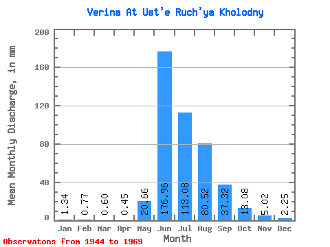
| Statistic | Jan | Feb | Mar | Apr | May | Jun | Jul | Aug | Sep | Oct | Nov | Dec | Annual |
|---|---|---|---|---|---|---|---|---|---|---|---|---|---|
| Mean | 1.34 | 0.78 | 0.60 | 0.45 | 20.66 | 176.96 | 113.06 | 80.51 | 37.32 | 13.08 | 5.03 | 2.25 | 447.21 |
| Standard Deviation | 0.73 | 0.48 | 0.40 | 0.30 | 27.62 | 46.17 | 41.48 | 28.95 | 17.45 | 4.49 | 2.45 | 0.96 | 98.83 |
| Min | 0.00 | 0.00 | 0.00 | 0.00 | 0.38 | 105.46 | 57.72 | 41.33 | 17.15 | 7.24 | 0.89 | 0.00 | 298.89 |
| Max | 2.58 | 1.67 | 1.58 | 1.13 | 86.49 | 269.67 | 227.05 | 133.90 | 105.45 | 27.53 | 12.80 | 3.74 | 617.63 |
| Coefficient of Variation | 0.55 | 0.62 | 0.67 | 0.68 | 1.34 | 0.26 | 0.37 | 0.36 | 0.47 | 0.34 | 0.49 | 0.43 | 0.22 |
 Return to R-Arctic Net Home Page