|
|
|||||||||||||||||
| Point ID: 8064 | Downloads | Plots | Site Data | Code: 1311 |
|
|
|||||||||||||||||
| Download | |
|---|---|
| Site Descriptor Information | Site Time Series Data |
| Link to all available data | |
|
|
| View: | Statistics | Time Series |
| Units: | m3/s |
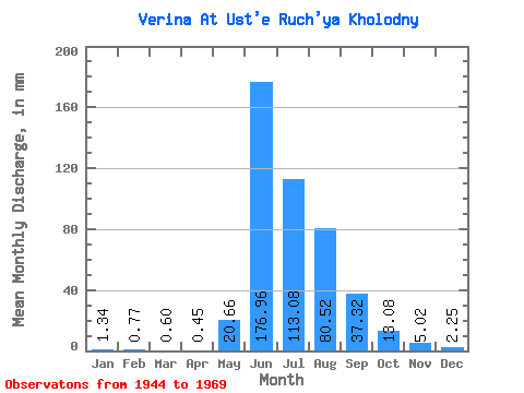
| Statistic | Jan | Feb | Mar | Apr | May | Jun | Jul | Aug | Sep | Oct | Nov | Dec | Annual |
|---|---|---|---|---|---|---|---|---|---|---|---|---|---|
| Mean | 1.34 | 0.78 | 0.60 | 0.45 | 20.66 | 176.96 | 113.06 | 80.51 | 37.32 | 13.08 | 5.03 | 2.25 | 447.21 |
| Standard Deviation | 0.73 | 0.48 | 0.40 | 0.30 | 27.62 | 46.17 | 41.48 | 28.95 | 17.45 | 4.49 | 2.45 | 0.96 | 98.83 |
| Min | 0.00 | 0.00 | 0.00 | 0.00 | 0.38 | 105.46 | 57.72 | 41.33 | 17.15 | 7.24 | 0.89 | 0.00 | 298.89 |
| Max | 2.58 | 1.67 | 1.58 | 1.13 | 86.49 | 269.67 | 227.05 | 133.90 | 105.45 | 27.53 | 12.80 | 3.74 | 617.63 |
| Coefficient of Variation | 0.55 | 0.62 | 0.67 | 0.68 | 1.34 | 0.26 | 0.37 | 0.36 | 0.47 | 0.34 | 0.49 | 0.43 | 0.22 |
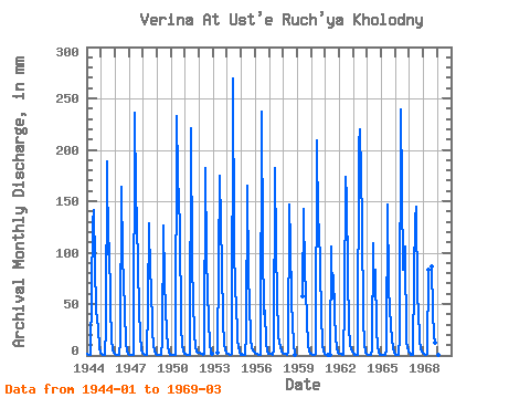
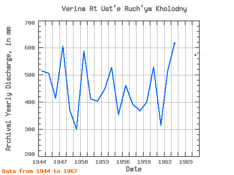
| Year | Jan | Feb | Mar | Apr | May | Jun | Jul | Aug | Sep | Oct | Nov | Dec | Annual | 1944 | 1.58 | 0.99 | 0.75 | 0.52 | 65.20 | 128.79 | 146.38 | 93.15 | 43.55 | 27.53 | 6.76 | 2.58 | 514.45 | 1945 | 1.50 | 0.54 | 0.42 | 0.32 | 26.70 | 189.17 | 101.47 | 113.11 | 49.34 | 14.97 | 6.36 | 2.99 | 505.84 | 1946 | 1.33 | 0.61 | 0.49 | 0.34 | 13.39 | 164.21 | 99.80 | 72.61 | 44.84 | 11.56 | 4.59 | 1.91 | 415.25 | 1947 | 1.08 | 0.83 | 0.53 | 0.25 | 0.38 | 235.86 | 163.01 | 133.90 | 44.19 | 20.29 | 4.99 | 2.41 | 606.22 | 1948 | 1.50 | 0.40 | 0.22 | 0.27 | 50.73 | 127.99 | 79.42 | 72.52 | 24.39 | 10.15 | 3.54 | 1.50 | 371.08 | 1949 | 0.60 | 0.17 | 0.23 | 0.35 | 13.39 | 126.38 | 75.60 | 46.66 | 23.02 | 9.06 | 2.74 | 1.08 | 298.89 | 1950 | 0.59 | 0.44 | 0.38 | 0.32 | 0.56 | 232.64 | 180.47 | 129.74 | 28.09 | 10.98 | 3.62 | 1.91 | 587.85 | 1951 | 1.16 | 0.91 | 0.77 | 0.38 | 1.08 | 221.37 | 90.65 | 55.81 | 21.41 | 9.48 | 3.94 | 2.99 | 410.75 | 1952 | 2.33 | 1.67 | 1.16 | 0.81 | 1.83 | 182.73 | 98.97 | 64.62 | 33.24 | 11.23 | 3.95 | 1.92 | 404.56 | 1953 | 0.00 | 0.00 | 0.00 | 0.00 | 3.00 | 174.68 | 132.24 | 88.16 | 33.49 | 10.64 | 5.47 | 2.83 | 449.40 | 1954 | 2.16 | 1.44 | 1.00 | 0.72 | 1.25 | 269.67 | 115.60 | 58.97 | 55.14 | 14.47 | 4.03 | 1.08 | 526.98 | 1955 | 1.33 | 0.98 | 0.76 | 0.79 | 20.29 | 165.02 | 80.09 | 52.65 | 17.15 | 7.24 | 4.59 | 3.58 | 354.31 | 1956 | 2.50 | 1.59 | 1.58 | 0.81 | 0.77 | 236.67 | 110.61 | 41.33 | 44.03 | 12.56 | 4.91 | 2.08 | 460.68 | 1957 | 2.16 | 1.52 | 1.16 | 0.75 | 4.57 | 182.73 | 106.45 | 60.63 | 18.76 | 8.65 | 3.62 | 2.41 | 393.22 | 1958 | 2.16 | 1.59 | 1.25 | 0.49 | 3.66 | 146.50 | 112.28 | 55.64 | 29.86 | 13.31 | 0.89 | 0.00 | 366.98 | 1959 | 0.00 | 0.00 | 0.00 | 0.00 | 59.71 | 142.48 | 80.84 | 67.45 | 33.57 | 11.31 | 4.03 | 2.08 | 400.14 | 1960 | 1.33 | 0.63 | 0.28 | 0.23 | 1.41 | 209.29 | 131.41 | 131.41 | 40.09 | 10.23 | 3.38 | 1.25 | 529.72 | 1961 | 0.69 | 0.22 | 0.01 | 0.00 | 0.41 | 105.46 | 57.72 | 80.76 | 41.38 | 16.72 | 7.89 | 2.83 | 313.50 | 1962 | 1.66 | 1.06 | 0.55 | 0.52 | 50.65 | 173.87 | 158.85 | 81.92 | 26.97 | 11.07 | 6.04 | 3.74 | 514.49 | 1963 | 2.25 | 0.83 | 0.29 | 0.05 | 0.72 | 205.27 | 227.05 | 133.90 | 35.10 | 11.14 | 2.90 | 1.25 | 617.63 | 1964 | 0.64 | 0.48 | 0.41 | 0.36 | 6.24 | 109.48 | 59.63 | 86.49 | 23.50 | 10.40 | 2.33 | 1.08 | 300.12 | 1965 | 0.60 | 0.50 | 0.47 | 0.36 | 4.74 | 146.50 | 69.61 | 46.16 | 30.11 | 14.55 | 7.73 | 3.24 | 324.83 | 1966 | 0.92 | 0.55 | 0.55 | 0.52 | 17.88 | 239.08 | 85.66 | 96.47 | 105.45 | 12.97 | 8.69 | 3.74 | 573.81 | 1967 | 2.58 | 0.98 | 0.80 | 0.97 | 81.42 | 131.21 | 149.70 | 58.80 | 44.52 | 15.64 | 5.88 | 2.58 | 492.24 | 1968 | 1.16 | 0.68 | 0.80 | 1.13 | 86.49 | 89.82 | 41.78 | 20.96 | 12.80 | 3.24 | 1969 | 1.00 | 0.55 | 0.73 |
|---|
 Return to R-Arctic Net Home Page