|
|
|||||||||||||||||
| Point ID: 8062 | Downloads | Plots | Site Data | Code: 1292 |
|
|
|||||||||||||||||
| Download | |
|---|---|
| Site Descriptor Information | Site Time Series Data |
| Link to all available data | |
|
|
| View: | Statistics | Time Series |
| Units: | mm |
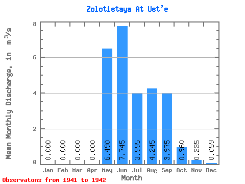
| Statistic | Jan | Feb | Mar | Apr | May | Jun | Jul | Aug | Sep | Oct | Nov | Dec | Annual |
|---|---|---|---|---|---|---|---|---|---|---|---|---|---|
| Mean | 0.00 | 0.00 | 0.00 | 0.00 | 6.49 | 7.75 | 4.00 | 4.25 | 3.98 | 0.96 | 0.23 | 0.06 | 2.31 |
| Standard Deviation | 0.00 | 0.00 | 0.00 | 0.00 | 2.35 | 1.44 | 2.23 | 1.58 | 2.62 | 0.54 | 0.16 | 0.01 | 0.91 |
| Min | 0.00 | 0.00 | 0.00 | 0.00 | 4.83 | 6.73 | 2.42 | 3.13 | 2.12 | 0.58 | 0.12 | 0.06 | 1.67 |
| Max | 0.00 | 0.00 | 0.00 | 0.00 | 8.15 | 8.76 | 5.57 | 5.36 | 5.83 | 1.34 | 0.35 | 0.06 | 2.95 |
| Coefficient of Variation | 0.36 | 0.18 | 0.56 | 0.37 | 0.66 | 0.56 | 0.69 | 0.09 | 0.39 |
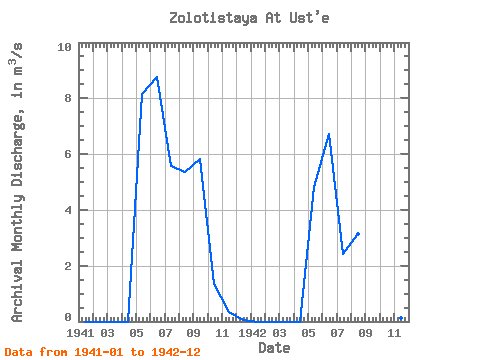
| Year | Jan | Feb | Mar | Apr | May | Jun | Jul | Aug | Sep | Oct | Nov | Dec | Annual | 1941 | 0.00 | 0.00 | 0.00 | 0.00 | 8.15 | 8.76 | 5.57 | 5.36 | 5.83 | 1.34 | 0.35 | 0.06 | 2.95 | 1942 | 0.00 | 0.00 | 0.00 | 0.00 | 4.83 | 6.73 | 2.42 | 3.13 | 2.12 | 0.58 | 0.12 | 0.06 | 1.67 |
|---|
 Return to R-Arctic Net Home Page