|
|
|||||||||||||||||
| Point ID: 8062 | Downloads | Plots | Site Data | Code: 1292 |
|
|
|||||||||||||||||
| Download | |
|---|---|
| Site Descriptor Information | Site Time Series Data |
| Link to all available data | |
|
|
| View: | Statistics | Time Series |
| Units: | m3/s |
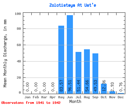
| Statistic | Jan | Feb | Mar | Apr | May | Jun | Jul | Aug | Sep | Oct | Nov | Dec | Annual |
|---|---|---|---|---|---|---|---|---|---|---|---|---|---|
| Mean | 0.00 | 0.00 | 0.00 | 0.00 | 83.56 | 96.52 | 51.44 | 54.65 | 49.53 | 12.36 | 2.93 | 0.76 | 350.30 |
| Standard Deviation | 0.00 | 0.00 | 0.00 | 0.00 | 30.23 | 17.89 | 28.68 | 20.30 | 32.69 | 6.92 | 2.03 | 0.07 | 137.89 |
| Min | 0.00 | 0.00 | 0.00 | 0.00 | 62.19 | 83.87 | 31.16 | 40.30 | 26.42 | 7.47 | 1.50 | 0.71 | 252.79 |
| Max | 0.00 | 0.00 | 0.00 | 0.00 | 104.94 | 109.16 | 71.71 | 69.01 | 72.65 | 17.25 | 4.36 | 0.81 | 447.80 |
| Coefficient of Variation | 0.36 | 0.18 | 0.56 | 0.37 | 0.66 | 0.56 | 0.69 | 0.09 | 0.39 |
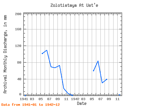
| Year | Jan | Feb | Mar | Apr | May | Jun | Jul | Aug | Sep | Oct | Nov | Dec | Annual | 1941 | 0.00 | 0.00 | 0.00 | 0.00 | 104.94 | 109.16 | 71.71 | 69.01 | 72.65 | 17.25 | 4.36 | 0.71 | 447.80 | 1942 | 0.00 | 0.00 | 0.00 | 0.00 | 62.19 | 83.87 | 31.16 | 40.30 | 26.42 | 7.47 | 1.50 | 0.81 | 252.79 |
|---|
 Return to R-Arctic Net Home Page