|
|
|||||||||||||||||
| Point ID: 8026 | Downloads | Plots | Site Data | Code: 1031 |
|
|
|||||||||||||||||
| Download | |
|---|---|
| Site Descriptor Information | Site Time Series Data |
| Link to all available data | |
|
|
| View: | Statistics | Time Series |
| Units: | mm |
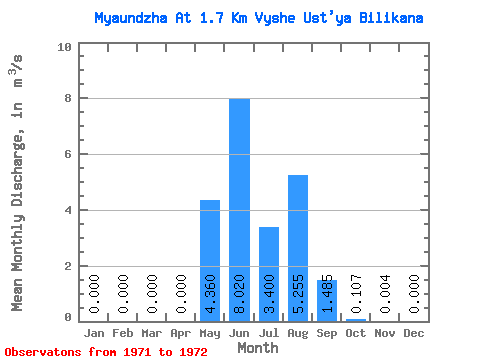
| Statistic | Jan | Feb | Mar | Apr | May | Jun | Jul | Aug | Sep | Oct | Nov | Dec | Annual |
|---|---|---|---|---|---|---|---|---|---|---|---|---|---|
| Mean | 0.00 | 0.00 | 0.00 | 0.00 | 4.36 | 8.02 | 3.40 | 5.25 | 1.48 | 0.11 | 0.00 | 0.00 | 1.89 |
| Standard Deviation | 0.00 | 0.00 | 0.00 | 0.00 | 0.37 | 3.51 | 2.35 | 5.54 | 1.14 | 0.08 | 0.01 | 0.00 | 0.61 |
| Min | 0.00 | 0.00 | 0.00 | 0.00 | 4.10 | 5.54 | 1.74 | 1.34 | 0.68 | 0.05 | 0.00 | 0.00 | 1.45 |
| Max | 0.00 | 0.00 | 0.00 | 0.00 | 4.62 | 10.50 | 5.06 | 9.17 | 2.29 | 0.16 | 0.01 | 0.00 | 2.32 |
| Coefficient of Variation | 0.08 | 0.44 | 0.69 | 1.05 | 0.77 | 0.72 | 1.41 | 0.33 |
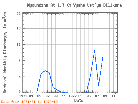
| Year | Jan | Feb | Mar | Apr | May | Jun | Jul | Aug | Sep | Oct | Nov | Dec | Annual | 1971 | 0.00 | 0.00 | 0.00 | 0.00 | 4.62 | 5.54 | 5.06 | 1.34 | 0.68 | 0.16 | 0.01 | 0.00 | 1.45 | 1972 | 0.00 | 0.00 | 0.00 | 0.00 | 4.10 | 10.50 | 1.74 | 9.17 | 2.29 | 0.05 | 0.00 | 0.00 | 2.32 |
|---|
 Return to R-Arctic Net Home Page