|
|
|||||||||||||||||
| Point ID: 8026 | Downloads | Plots | Site Data | Code: 1031 |
|
|
|||||||||||||||||
| Download | |
|---|---|
| Site Descriptor Information | Site Time Series Data |
| Link to all available data | |
|
|
| View: | Statistics | Time Series |
| Units: | m3/s |
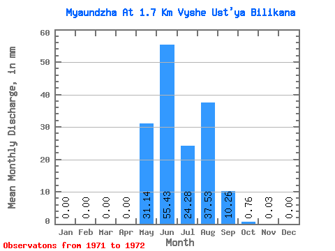
| Statistic | Jan | Feb | Mar | Apr | May | Jun | Jul | Aug | Sep | Oct | Nov | Dec | Annual |
|---|---|---|---|---|---|---|---|---|---|---|---|---|---|
| Mean | 0.00 | 0.00 | 0.00 | 0.00 | 31.14 | 55.43 | 24.28 | 37.53 | 10.26 | 0.76 | 0.03 | 0.00 | 158.72 |
| Standard Deviation | 0.00 | 0.00 | 0.00 | 0.00 | 2.63 | 24.24 | 16.77 | 39.54 | 7.87 | 0.55 | 0.04 | 0.00 | 51.79 |
| Min | 0.00 | 0.00 | 0.00 | 0.00 | 29.28 | 38.29 | 12.43 | 9.57 | 4.70 | 0.38 | 0.00 | 0.00 | 122.10 |
| Max | 0.00 | 0.00 | 0.00 | 0.00 | 33.00 | 72.58 | 36.13 | 65.49 | 15.83 | 1.15 | 0.06 | 0.00 | 195.34 |
| Coefficient of Variation | 0.08 | 0.44 | 0.69 | 1.05 | 0.77 | 0.72 | 1.41 | 0.33 |
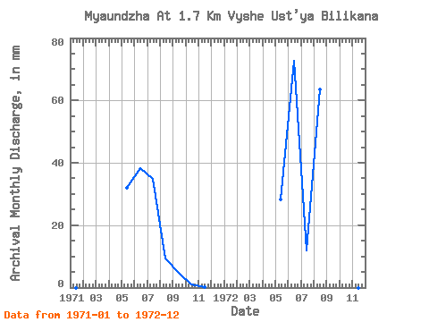
| Year | Jan | Feb | Mar | Apr | May | Jun | Jul | Aug | Sep | Oct | Nov | Dec | Annual | 1971 | 0.00 | 0.00 | 0.00 | 0.00 | 33.00 | 38.29 | 36.13 | 9.57 | 4.70 | 1.15 | 0.06 | 0.00 | 122.10 | 1972 | 0.00 | 0.00 | 0.00 | 0.00 | 29.28 | 72.58 | 12.43 | 65.49 | 15.83 | 0.38 | 0.00 | 0.00 | 195.34 |
|---|
 Return to R-Arctic Net Home Page