|
|
|||||||||||||||||
| Point ID: 8025 | Downloads | Plots | Site Data | Code: 1025 |
|
|
|||||||||||||||||
| Download | |
|---|---|
| Site Descriptor Information | Site Time Series Data |
| Link to all available data | |
|
|
| View: | Statistics | Time Series |
| Units: | mm |
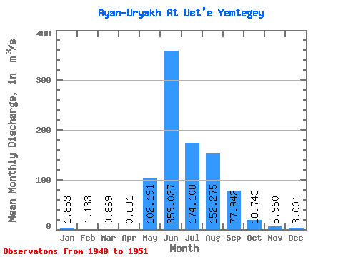
| Statistic | Jan | Feb | Mar | Apr | May | Jun | Jul | Aug | Sep | Oct | Nov | Dec | Annual |
|---|---|---|---|---|---|---|---|---|---|---|---|---|---|
| Mean | 1.85 | 1.13 | 0.87 | 0.68 | 102.19 | 359.03 | 174.11 | 152.28 | 77.94 | 18.74 | 5.96 | 3.00 | 78.48 |
| Standard Deviation | 1.17 | 1.01 | 0.83 | 0.65 | 74.72 | 182.39 | 95.43 | 109.67 | 42.56 | 11.70 | 2.84 | 1.65 | 26.03 |
| Min | 0.50 | 0.24 | 0.07 | 0.04 | 7.59 | 93.30 | 0.00 | 0.00 | 0.00 | 0.00 | 0.00 | 0.00 | 29.58 |
| Max | 4.69 | 3.61 | 2.90 | 1.84 | 251.00 | 725.00 | 372.00 | 431.00 | 125.00 | 41.10 | 10.40 | 6.14 | 118.02 |
| Coefficient of Variation | 0.63 | 0.89 | 0.95 | 0.95 | 0.73 | 0.51 | 0.55 | 0.72 | 0.55 | 0.62 | 0.48 | 0.55 | 0.33 |
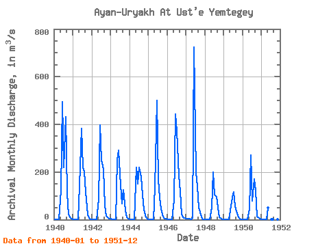
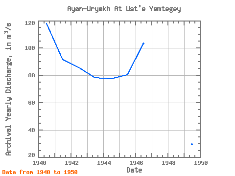
| Year | Jan | Feb | Mar | Apr | May | Jun | Jul | Aug | Sep | Oct | Nov | Dec | Annual | 1940 | 2.71 | 1.66 | 1.69 | 1.60 | 121.00 | 494.00 | 219.00 | 431.00 | 109.00 | 22.30 | 7.93 | 4.33 | 118.02 | 1941 | 1.94 | 1.02 | 0.80 | 0.65 | 141.00 | 384.00 | 218.00 | 202.00 | 117.00 | 22.30 | 7.70 | 2.77 | 91.60 | 1942 | 1.53 | 0.73 | 0.49 | 0.41 | 83.80 | 397.00 | 250.00 | 212.00 | 58.10 | 14.50 | 6.92 | 3.94 | 85.78 | 1943 | 2.94 | 2.54 | 1.62 | 1.61 | 251.00 | 290.00 | 146.00 | 68.50 | 125.00 | 37.50 | 8.73 | 4.29 | 78.31 | 1944 | 1.76 | 0.65 | 0.36 | 0.20 | 220.00 | 151.00 | 219.00 | 178.00 | 106.00 | 41.10 | 10.40 | 3.43 | 77.66 | 1945 | 1.48 | 0.60 | 0.36 | 0.24 | 136.00 | 500.00 | 167.00 | 94.50 | 44.30 | 12.60 | 5.11 | 3.25 | 80.45 | 1946 | 1.62 | 0.99 | 1.04 | 0.87 | 81.60 | 443.00 | 372.00 | 184.00 | 119.00 | 22.10 | 7.54 | 6.14 | 103.33 | 1947 | 4.69 | 3.61 | 2.90 | 1.84 | 7.59 | 725.00 | 200.00 | 138.00 | 49.50 | 20.50 | 4.46 | 1.41 | 96.62 | 1948 | 0.61 | 0.32 | 0.24 | 0.16 | 49.80 | 200.00 | 104.00 | 94.70 | 49.30 | 9.28 | 3.77 | 1.88 | 42.84 | 1949 | 0.72 | 0.24 | 0.07 | 0.04 | 39.20 | 93.30 | 116.00 | 54.60 | 37.10 | 9.13 | 3.18 | 1.35 | 29.58 | 1950 | 0.50 | 0.43 | 0.29 | 0.15 | 44.50 | 272.00 | 78.30 | 170.00 | 121.00 | 13.60 | 5.78 | 3.22 | 59.15 | 1951 | 1.74 | 0.80 | 0.57 | 0.40 | 50.80 | 0.00 | 0.00 | 0.00 | 0.00 | 0.00 | 0.00 |
|---|
 Return to R-Arctic Net Home Page