|
|
|||||||||||||||||
| Point ID: 8008 | Downloads | Plots | Site Data | Code: 3809 |
|
|
|||||||||||||||||
| Download | |
|---|---|
| Site Descriptor Information | Site Time Series Data |
| Link to all available data | |
|
|
| View: | Statistics | Time Series |
| Units: | mm |
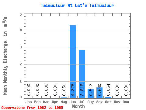
| Statistic | Jan | Feb | Mar | Apr | May | Jun | Jul | Aug | Sep | Oct | Nov | Dec | Annual |
|---|---|---|---|---|---|---|---|---|---|---|---|---|---|
| Mean | 0.00 | 0.00 | 0.00 | 0.00 | 0.05 | 4.28 | 2.82 | 0.54 | 0.63 | 0.06 | 0.00 | 0.00 | 0.70 |
| Standard Deviation | 0.00 | 0.00 | 0.00 | 0.00 | 0.10 | 1.29 | 3.95 | 0.52 | 0.37 | 0.08 | 0.00 | 0.00 | 0.33 |
| Min | 0.00 | 0.00 | 0.00 | 0.00 | 0.00 | 2.38 | 0.22 | 0.08 | 0.30 | 0.01 | 0.00 | 0.00 | 0.45 |
| Max | 0.00 | 0.00 | 0.00 | 0.00 | 0.20 | 5.29 | 8.70 | 1.22 | 1.01 | 0.18 | 0.00 | 0.00 | 1.16 |
| Coefficient of Variation | 2.00 | 0.30 | 1.40 | 0.96 | 0.59 | 1.27 | 0.47 |
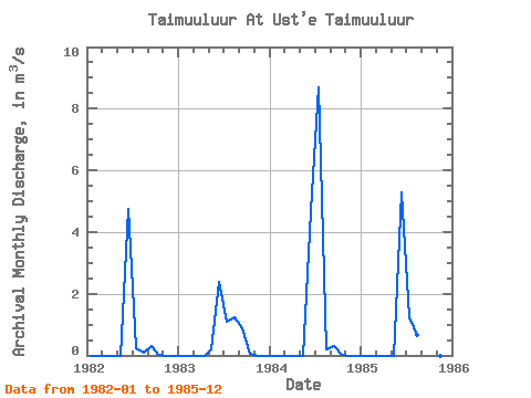
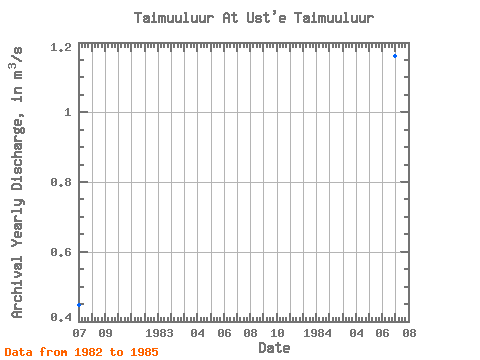
| Year | Jan | Feb | Mar | Apr | May | Jun | Jul | Aug | Sep | Oct | Nov | Dec | Annual | 1982 | 0.00 | 0.00 | 0.00 | 0.00 | 0.00 | 4.75 | 0.22 | 0.08 | 0.30 | 0.01 | 0.00 | 0.00 | 0.45 | 1983 | 0.00 | 0.00 | 0.00 | 0.00 | 0.20 | 2.38 | 1.10 | 1.22 | 0.89 | 0.06 | 0.00 | 0.00 | 0.49 | 1984 | 0.00 | 0.00 | 0.00 | 0.00 | 0.00 | 4.69 | 8.70 | 0.20 | 0.32 | 0.01 | 0.00 | 0.00 | 1.16 | 1985 | 0.00 | 0.00 | 0.00 | 0.00 | 0.00 | 5.29 | 1.25 | 0.67 | 1.01 | 0.18 | 0.00 | 0.00 | 0.70 |
|---|
 Return to R-Arctic Net Home Page