|
|
|||||||||||||||||
| Point ID: 8008 | Downloads | Plots | Site Data | Code: 3809 |
|
|
|||||||||||||||||
| Download | |
|---|---|
| Site Descriptor Information | Site Time Series Data |
| Link to all available data | |
|
|
| View: | Statistics | Time Series |
| Units: | m3/s |
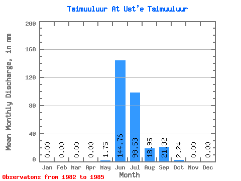
| Statistic | Jan | Feb | Mar | Apr | May | Jun | Jul | Aug | Sep | Oct | Nov | Dec | Annual |
|---|---|---|---|---|---|---|---|---|---|---|---|---|---|
| Mean | 0.00 | 0.00 | 0.00 | 0.00 | 1.75 | 144.74 | 98.50 | 18.96 | 21.32 | 2.23 | 0.00 | 0.00 | 287.75 |
| Standard Deviation | 0.00 | 0.00 | 0.00 | 0.00 | 3.50 | 43.77 | 138.02 | 18.14 | 12.62 | 2.84 | 0.00 | 0.00 | 134.73 |
| Min | 0.00 | 0.00 | 0.00 | 0.00 | 0.00 | 80.53 | 7.69 | 2.76 | 10.15 | 0.24 | 0.00 | 0.00 | 183.96 |
| Max | 0.00 | 0.00 | 0.00 | 0.00 | 6.99 | 179.00 | 304.16 | 42.65 | 34.18 | 6.29 | 0.00 | 0.00 | 477.83 |
| Coefficient of Variation | 2.00 | 0.30 | 1.40 | 0.96 | 0.59 | 1.27 | 0.47 |
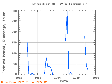
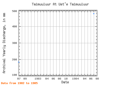
| Year | Jan | Feb | Mar | Apr | May | Jun | Jul | Aug | Sep | Oct | Nov | Dec | Annual | 1982 | 0.00 | 0.00 | 0.00 | 0.00 | 0.00 | 160.73 | 7.69 | 2.76 | 10.15 | 0.32 | 0.00 | 0.00 | 183.96 | 1983 | 0.00 | 0.00 | 0.00 | 0.00 | 6.99 | 80.53 | 38.46 | 42.65 | 30.12 | 2.06 | 0.00 | 0.00 | 200.82 | 1984 | 0.00 | 0.00 | 0.00 | 0.00 | 0.00 | 158.70 | 304.16 | 6.99 | 10.83 | 0.24 | 0.00 | 0.00 | 477.83 | 1985 | 0.00 | 0.00 | 0.00 | 0.00 | 0.00 | 179.00 | 43.70 | 23.42 | 34.18 | 6.29 | 0.00 | 0.00 | 288.41 |
|---|
 Return to R-Arctic Net Home Page