|
|
|||||||||||||||||
| Point ID: 8003 | Downloads | Plots | Site Data | Code: 3667 |
|
|
|||||||||||||||||
| Download | |
|---|---|
| Site Descriptor Information | Site Time Series Data |
| Link to all available data | |
| View: | Time Series | All |
| Units: | m3/s |
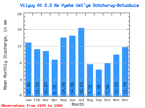
| Statistic | Jan | Feb | Mar | Apr | May | Jun | Jul | Aug | Sep | Oct | Nov | Dec | Annual |
|---|---|---|---|---|---|---|---|---|---|---|---|---|---|
| Mean | 12.86 | 11.40 | 10.87 | 8.75 | 14.05 | 14.55 | 16.41 | 7.72 | 6.38 | 7.94 | 10.03 | 11.79 | 132.12 |
| Standard Deviation | 2.17 | 2.13 | 2.02 | 1.61 | 3.18 | 7.89 | 10.75 | 5.87 | 3.04 | 1.49 | 1.59 | 1.75 | 23.64 |
| Min | 8.33 | 7.93 | 7.49 | 6.25 | 9.37 | 9.11 | 3.34 | 3.54 | 4.36 | 4.96 | 6.87 | 8.37 | 95.30 |
| Max | 15.60 | 14.50 | 13.56 | 10.69 | 19.46 | 35.26 | 39.09 | 21.79 | 16.74 | 10.11 | 12.86 | 14.19 | 178.10 |
| Coefficient of Variation | 0.17 | 0.19 | 0.18 | 0.18 | 0.23 | 0.54 | 0.66 | 0.76 | 0.48 | 0.19 | 0.16 | 0.15 | 0.18 |
 Return to R-Arctic Net Home Page