|
|
|||||||||||||||||
| Point ID: 8003 | Downloads | Plots | Site Data | Code: 3667 |
|
|
|||||||||||||||||
| Download | |
|---|---|
| Site Descriptor Information | Site Time Series Data |
| Link to all available data | |
| View: | Time Series | All |
| Units: | mm |
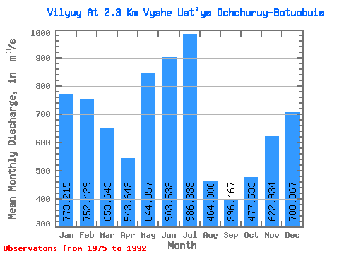
| Statistic | Jan | Feb | Mar | Apr | May | Jun | Jul | Aug | Sep | Oct | Nov | Dec | Annual |
|---|---|---|---|---|---|---|---|---|---|---|---|---|---|
| Mean | 773.22 | 752.43 | 653.64 | 543.64 | 844.86 | 903.53 | 986.33 | 464.00 | 396.47 | 477.53 | 622.93 | 708.87 | 674.01 |
| Standard Deviation | 130.77 | 140.41 | 121.25 | 99.73 | 191.02 | 489.85 | 646.50 | 352.67 | 188.97 | 89.67 | 98.51 | 105.24 | 120.62 |
| Min | 501.00 | 523.00 | 450.00 | 388.00 | 563.00 | 566.00 | 201.00 | 213.00 | 271.00 | 298.00 | 427.00 | 503.00 | 486.17 |
| Max | 938.00 | 957.00 | 815.00 | 664.00 | 1170.00 | 2190.00 | 2350.00 | 1310.00 | 1040.00 | 608.00 | 799.00 | 853.00 | 908.58 |
| Coefficient of Variation | 0.17 | 0.19 | 0.18 | 0.18 | 0.23 | 0.54 | 0.66 | 0.76 | 0.48 | 0.19 | 0.16 | 0.15 | 0.18 |
 Return to R-Arctic Net Home Page