|
|
|||||||||||||||||
| Point ID: 7991 | Downloads | Plots | Site Data | Code: 3641 |
|
|
|||||||||||||||||
| Download | |
|---|---|
| Site Descriptor Information | Site Time Series Data |
| Link to all available data | |
|
|
| View: | Statistics | Time Series |
| Units: | mm |
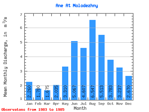
| Statistic | Jan | Feb | Mar | Apr | May | Jun | Jul | Aug | Sep | Oct | Nov | Dec | Annual |
|---|---|---|---|---|---|---|---|---|---|---|---|---|---|
| Mean | 2.26 | 1.78 | 1.68 | 2.04 | 3.31 | 5.07 | 4.61 | 6.55 | 5.51 | 3.78 | 3.24 | 2.67 | 3.16 |
| Standard Deviation | 0.03 | 0.35 | 0.47 | 0.81 | 1.16 | 1.00 | 1.02 | 4.58 | 2.78 | 0.94 | 0.80 | 0.43 | 0.40 |
| Min | 2.24 | 1.53 | 1.34 | 1.46 | 2.48 | 4.17 | 3.47 | 2.94 | 2.96 | 2.72 | 2.46 | 2.19 | 2.88 |
| Max | 2.28 | 2.03 | 2.01 | 2.61 | 4.64 | 6.14 | 5.43 | 11.70 | 8.47 | 4.50 | 4.06 | 3.03 | 3.44 |
| Coefficient of Variation | 0.01 | 0.20 | 0.28 | 0.40 | 0.35 | 0.20 | 0.22 | 0.70 | 0.50 | 0.25 | 0.25 | 0.16 | 0.12 |
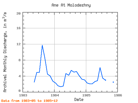
| Year | Jan | Feb | Mar | Apr | May | Jun | Jul | Aug | Sep | Oct | Nov | Dec | Annual | 1983 | 2.48 | 4.89 | 4.92 | 11.70 | 8.47 | 4.50 | 4.06 | 2.79 | 1984 | 2.28 | 1.53 | 1.34 | 1.46 | 4.64 | 4.17 | 5.43 | 5.00 | 5.11 | 4.13 | 3.19 | 3.03 | 3.44 | 1985 | 2.24 | 2.03 | 2.01 | 2.61 | 2.81 | 6.14 | 3.47 | 2.94 | 2.96 | 2.72 | 2.46 | 2.19 | 2.88 |
|---|
 Return to R-Arctic Net Home Page