|
|
|||||||||||||||||
| Point ID: 7991 | Downloads | Plots | Site Data | Code: 3641 |
|
|
|||||||||||||||||
| Download | |
|---|---|
| Site Descriptor Information | Site Time Series Data |
| Link to all available data | |
|
|
| View: | Statistics | Time Series |
| Units: | m3/s |
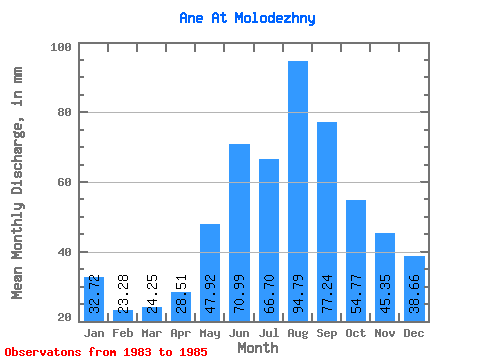
| Statistic | Jan | Feb | Mar | Apr | May | Jun | Jul | Aug | Sep | Oct | Nov | Dec | Annual |
|---|---|---|---|---|---|---|---|---|---|---|---|---|---|
| Mean | 32.72 | 23.48 | 24.25 | 28.51 | 47.91 | 70.99 | 66.69 | 94.77 | 77.25 | 54.77 | 45.35 | 38.65 | 539.43 |
| Standard Deviation | 0.41 | 4.66 | 6.86 | 11.39 | 16.84 | 13.97 | 14.72 | 66.30 | 38.91 | 13.60 | 11.22 | 6.26 | 67.65 |
| Min | 32.43 | 20.18 | 19.40 | 20.46 | 35.90 | 58.42 | 50.23 | 42.56 | 41.47 | 39.37 | 34.47 | 31.70 | 491.60 |
| Max | 33.01 | 26.77 | 29.10 | 36.57 | 67.17 | 86.03 | 78.60 | 169.37 | 118.67 | 65.14 | 56.88 | 43.86 | 587.27 |
| Coefficient of Variation | 0.01 | 0.20 | 0.28 | 0.40 | 0.35 | 0.20 | 0.22 | 0.70 | 0.50 | 0.25 | 0.25 | 0.16 | 0.12 |
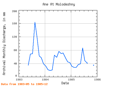
| Year | Jan | Feb | Mar | Apr | May | Jun | Jul | Aug | Sep | Oct | Nov | Dec | Annual | 1983 | 35.90 | 68.51 | 71.22 | 169.37 | 118.67 | 65.14 | 56.88 | 40.39 | 1984 | 33.01 | 20.18 | 19.40 | 20.46 | 67.17 | 58.42 | 78.60 | 72.38 | 71.59 | 59.78 | 44.69 | 43.86 | 587.27 | 1985 | 32.43 | 26.77 | 29.10 | 36.57 | 40.68 | 86.03 | 50.23 | 42.56 | 41.47 | 39.37 | 34.47 | 31.70 | 491.60 |
|---|
 Return to R-Arctic Net Home Page