|
|
|||||||||||||||||
| Point ID: 7969 | Downloads | Plots | Site Data | Code: 3610 |
|
|
|||||||||||||||||
| Download | |
|---|---|
| Site Descriptor Information | Site Time Series Data |
| Link to all available data | |
| View: | Time Series | All |
| Units: | m3/s |
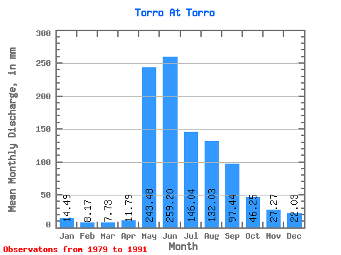
| Statistic | Jan | Feb | Mar | Apr | May | Jun | Jul | Aug | Sep | Oct | Nov | Dec | Annual |
|---|---|---|---|---|---|---|---|---|---|---|---|---|---|
| Mean | 14.49 | 8.24 | 7.73 | 11.79 | 243.45 | 259.20 | 146.02 | 132.01 | 97.44 | 46.25 | 27.27 | 22.02 | 1030.41 |
| Standard Deviation | 8.63 | 5.28 | 6.63 | 5.67 | 87.38 | 147.28 | 90.95 | 119.52 | 53.80 | 18.63 | 12.45 | 12.64 | 407.99 |
| Min | 3.94 | 1.44 | 1.09 | 3.56 | 128.52 | 118.55 | 23.24 | 17.20 | 26.81 | 17.20 | 12.58 | 6.83 | 576.54 |
| Max | 27.83 | 19.86 | 24.55 | 24.01 | 413.51 | 620.05 | 332.12 | 435.83 | 194.40 | 74.17 | 45.36 | 41.35 | 1694.93 |
| Coefficient of Variation | 0.60 | 0.64 | 0.86 | 0.48 | 0.36 | 0.57 | 0.62 | 0.91 | 0.55 | 0.40 | 0.46 | 0.57 | 0.40 |
 Return to R-Arctic Net Home Page