|
|
|||||||||||||||||
| Point ID: 7969 | Downloads | Plots | Site Data | Code: 3610 |
|
|
|||||||||||||||||
| Download | |
|---|---|
| Site Descriptor Information | Site Time Series Data |
| Link to all available data | |
| View: | Time Series | All |
| Units: | mm |
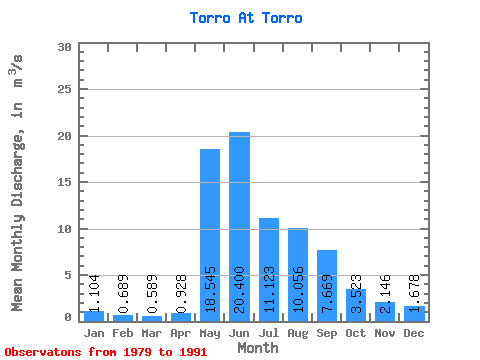
| Statistic | Jan | Feb | Mar | Apr | May | Jun | Jul | Aug | Sep | Oct | Nov | Dec | Annual |
|---|---|---|---|---|---|---|---|---|---|---|---|---|---|
| Mean | 1.10 | 0.69 | 0.59 | 0.93 | 18.55 | 20.40 | 11.12 | 10.06 | 7.67 | 3.52 | 2.15 | 1.68 | 6.66 |
| Standard Deviation | 0.66 | 0.44 | 0.51 | 0.45 | 6.66 | 11.59 | 6.93 | 9.11 | 4.24 | 1.42 | 0.98 | 0.96 | 2.64 |
| Min | 0.30 | 0.12 | 0.08 | 0.28 | 9.79 | 9.33 | 1.77 | 1.31 | 2.11 | 1.31 | 0.99 | 0.52 | 3.73 |
| Max | 2.12 | 1.66 | 1.87 | 1.89 | 31.50 | 48.80 | 25.30 | 33.20 | 15.30 | 5.65 | 3.57 | 3.15 | 10.96 |
| Coefficient of Variation | 0.60 | 0.64 | 0.86 | 0.48 | 0.36 | 0.57 | 0.62 | 0.91 | 0.55 | 0.40 | 0.46 | 0.57 | 0.40 |
 Return to R-Arctic Net Home Page