|
|
|||||||||||||||||
| Point ID: 796 | Downloads | Plots | Site Data | Code: 07JD004 |
|
|
|||||||||||||||||
| Download | |
|---|---|
| Site Descriptor Information | Site Time Series Data |
| Link to all available data | |
| View: | Time Series | All |
| Units: | m3/s |
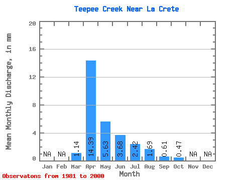
| Statistic | Jan | Feb | Mar | Apr | May | Jun | Jul | Aug | Sep | Oct | Nov | Dec | Annual |
|---|---|---|---|---|---|---|---|---|---|---|---|---|---|
| Mean | 1.13 | 14.39 | 5.64 | 3.67 | 2.42 | 1.70 | 0.60 | 0.47 | |||||
| Standard Deviation | 2.65 | 11.79 | 6.19 | 5.17 | 4.60 | 4.71 | 2.17 | 1.26 | |||||
| Min | 0.00 | 0.21 | 0.00 | 0.00 | 0.00 | 0.00 | 0.00 | 0.00 | |||||
| Max | 8.78 | 38.12 | 22.05 | 17.40 | 17.86 | 19.59 | 9.70 | 5.43 | |||||
| Coefficient of Variation | 2.34 | 0.82 | 1.10 | 1.41 | 1.90 | 2.77 | 3.59 | 2.71 |
 Return to R-Arctic Net Home Page