|
|
|||||||||||||||||
| Point ID: 796 | Downloads | Plots | Site Data | Code: 07JD004 |
|
|
|||||||||||||||||
| Download | |
|---|---|
| Site Descriptor Information | Site Time Series Data |
| Link to all available data | |
| View: | Time Series | All |
| Units: | mm |
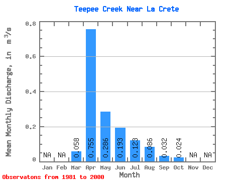
| Statistic | Jan | Feb | Mar | Apr | May | Jun | Jul | Aug | Sep | Oct | Nov | Dec | Annual |
|---|---|---|---|---|---|---|---|---|---|---|---|---|---|
| Mean | 0.06 | 0.76 | 0.29 | 0.19 | 0.12 | 0.09 | 0.03 | 0.02 | |||||
| Standard Deviation | 0.14 | 0.62 | 0.32 | 0.27 | 0.23 | 0.24 | 0.11 | 0.06 | |||||
| Min | 0.00 | 0.01 | 0.00 | 0.00 | 0.00 | 0.00 | 0.00 | 0.00 | |||||
| Max | 0.45 | 2.00 | 1.12 | 0.91 | 0.91 | 0.99 | 0.51 | 0.28 | |||||
| Coefficient of Variation | 2.34 | 0.82 | 1.10 | 1.41 | 1.90 | 2.77 | 3.59 | 2.71 |
 Return to R-Arctic Net Home Page