|
|
|||||||||||||||||
| Point ID: 7956 | Downloads | Plots | Site Data | Code: 3594 |
|
|
|||||||||||||||||
| Download | |
|---|---|
| Site Descriptor Information | Site Time Series Data |
| Link to all available data | |
|
|
| View: | Statistics | Time Series |
| Units: | mm |
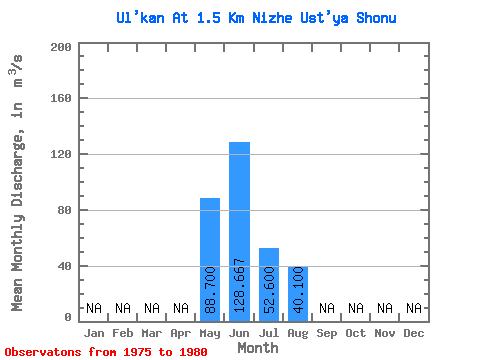
| Statistic | Jan | Feb | Mar | Apr | May | Jun | Jul | Aug | Sep | Oct | Nov | Dec | Annual |
|---|---|---|---|---|---|---|---|---|---|---|---|---|---|
| Mean | 88.70 | 128.67 | 52.60 | 40.10 | |||||||||
| Standard Deviation | 15.72 | 23.19 | 20.27 | 9.30 | |||||||||
| Min | 70.60 | 110.00 | 34.80 | 32.50 | |||||||||
| Max | 98.90 | 174.00 | 91.60 | 56.00 | |||||||||
| Coefficient of Variation | 0.18 | 0.18 | 0.39 | 0.23 |
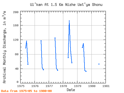
| Year | Jan | Feb | Mar | Apr | May | Jun | Jul | Aug | Sep | Oct | Nov | Dec | Annual | 1975 | 96.60 | 117.00 | 52.10 | 1976 | 117.00 | 43.30 | 36.60 | 1977 | 125.00 | 41.20 | 35.30 | 1978 | 70.60 | 174.00 | 91.60 | 56.00 | 1979 | 98.90 | 110.00 | 34.80 | 32.50 | 1980 | 129.00 | 52.60 | 40.10 |
|---|
 Return to R-Arctic Net Home Page