|
|
|||||||||||||||||
| Point ID: 7956 | Downloads | Plots | Site Data | Code: 3594 |
|
|
|||||||||||||||||
| Download | |
|---|---|
| Site Descriptor Information | Site Time Series Data |
| Link to all available data | |

|
|
| View: | Statistics | Time Series |
| Units: | m3/s |
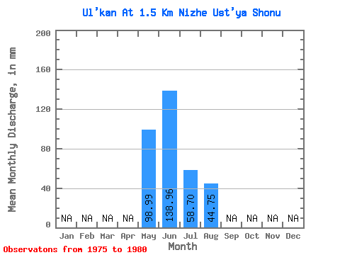
| Statistic | Jan | Feb | Mar | Apr | May | Jun | Jul | Aug | Sep | Oct | Nov | Dec | Annual |
|---|---|---|---|---|---|---|---|---|---|---|---|---|---|
| Mean | 98.97 | 138.96 | 58.69 | 44.74 | |||||||||
| Standard Deviation | 17.54 | 25.05 | 22.62 | 10.38 | |||||||||
| Min | 78.78 | 118.80 | 38.83 | 36.27 | |||||||||
| Max | 110.36 | 187.92 | 102.21 | 62.49 | |||||||||
| Coefficient of Variation | 0.18 | 0.18 | 0.39 | 0.23 |
| Year | Jan | Feb | Mar | Apr | May | Jun | Jul | Aug | Sep | Oct | Nov | Dec | Annual | 1975 | 107.79 | 126.36 | 58.13 | 1976 | 126.36 | 48.32 | 40.84 | 1977 | 135.00 | 45.97 | 39.39 | 1978 | 78.78 | 187.92 | 102.21 | 62.49 | 1979 | 110.36 | 118.80 | 38.83 | 36.27 | 1980 | 139.32 | 58.69 | 44.74 |
|---|
 Return to R-Arctic Net Home Page