|
|
|||||||||||||||||
| Point ID: 7954 | Downloads | Plots | Site Data | Code: 3592 |
|
|
|||||||||||||||||
| Download | |
|---|---|
| Site Descriptor Information | Site Time Series Data |
| Link to all available data | |
|
|
| View: | Statistics | Time Series |
| Units: | mm |
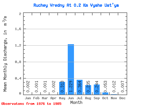
| Statistic | Jan | Feb | Mar | Apr | May | Jun | Jul | Aug | Sep | Oct | Nov | Dec | Annual |
|---|---|---|---|---|---|---|---|---|---|---|---|---|---|
| Mean | 0.00 | 0.00 | 0.00 | 0.00 | 0.31 | 1.23 | 0.36 | 0.23 | 0.24 | 0.05 | 0.01 | 0.01 | 0.24 |
| Standard Deviation | 0.00 | 0.00 | 0.00 | 0.00 | 0.13 | 0.40 | 0.20 | 0.12 | 0.13 | 0.02 | 0.01 | 0.01 | 0.08 |
| Min | 0.00 | 0.00 | 0.00 | 0.00 | 0.18 | 0.57 | 0.13 | 0.07 | 0.10 | 0.03 | 0.01 | 0.00 | 0.18 |
| Max | 0.00 | 0.00 | 0.00 | 0.00 | 0.49 | 2.07 | 0.63 | 0.47 | 0.40 | 0.07 | 0.02 | 0.01 | 0.30 |
| Coefficient of Variation | 0.89 | 1.41 | 2.00 | 0.76 | 0.42 | 0.32 | 0.54 | 0.53 | 0.52 | 0.42 | 0.65 | 0.69 | 0.34 |
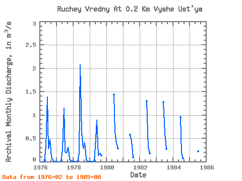
| Year | Jan | Feb | Mar | Apr | May | Jun | Jul | Aug | Sep | Oct | Nov | Dec | Annual | 1976 | 0.00 | 0.00 | 0.00 | 0.32 | 1.38 | 0.27 | 0.47 | 0.10 | 0.03 | 0.01 | 0.00 | 1977 | 0.00 | 0.00 | 0.00 | 0.00 | 0.26 | 1.15 | 0.21 | 0.19 | 0.31 | 0.07 | 0.02 | 0.01 | 0.18 | 1978 | 0.00 | 0.00 | 0.00 | 0.00 | 0.18 | 2.07 | 0.63 | 0.28 | 0.40 | 0.06 | 0.01 | 0.00 | 0.30 | 1979 | 0.00 | 0.00 | 0.00 | 0.00 | 0.49 | 0.89 | 0.13 | 0.18 | 0.13 | 1980 | 1.44 | 0.63 | 0.39 | 0.28 | 1981 | 0.57 | 0.44 | 0.09 | 1982 | 1.30 | 0.31 | 0.18 | 1983 | 1.27 | 0.61 | 0.27 | 1984 | 0.95 | 0.19 | 0.07 | 1985 | 1.27 | 0.22 | 0.24 |
|---|
 Return to R-Arctic Net Home Page