|
|
|||||||||||||||||
| Point ID: 7954 | Downloads | Plots | Site Data | Code: 3592 |
|
|
|||||||||||||||||
| Download | |
|---|---|
| Site Descriptor Information | Site Time Series Data |
| Link to all available data | |
|
|
| View: | Statistics | Time Series |
| Units: | m3/s |
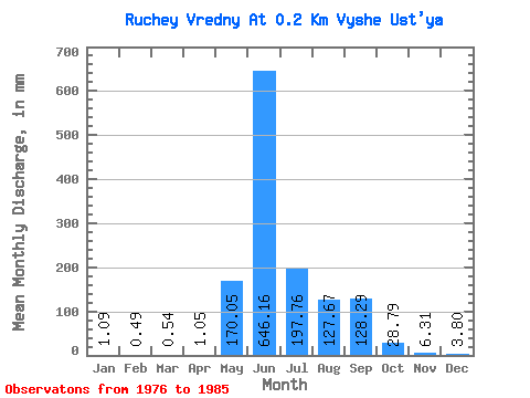
| Statistic | Jan | Feb | Mar | Apr | May | Jun | Jul | Aug | Sep | Oct | Nov | Dec | Annual |
|---|---|---|---|---|---|---|---|---|---|---|---|---|---|
| Mean | 1.27 | 0.49 | 0.27 | 1.18 | 169.75 | 646.16 | 197.73 | 127.82 | 128.29 | 28.79 | 6.31 | 3.62 | 1564.13 |
| Standard Deviation | 1.13 | 0.70 | 0.54 | 0.90 | 71.43 | 208.57 | 106.97 | 68.01 | 66.36 | 12.01 | 4.11 | 2.51 | 534.90 |
| Min | 0.00 | 0.00 | 0.00 | 0.00 | 97.78 | 299.68 | 70.62 | 35.85 | 52.58 | 15.21 | 3.68 | 2.17 | 1185.90 |
| Max | 2.17 | 1.48 | 1.09 | 2.10 | 266.17 | 1088.33 | 342.22 | 255.31 | 210.30 | 38.02 | 11.04 | 6.52 | 1942.36 |
| Coefficient of Variation | 0.89 | 1.41 | 2.00 | 0.76 | 0.42 | 0.32 | 0.54 | 0.53 | 0.52 | 0.42 | 0.65 | 0.69 | 0.34 |
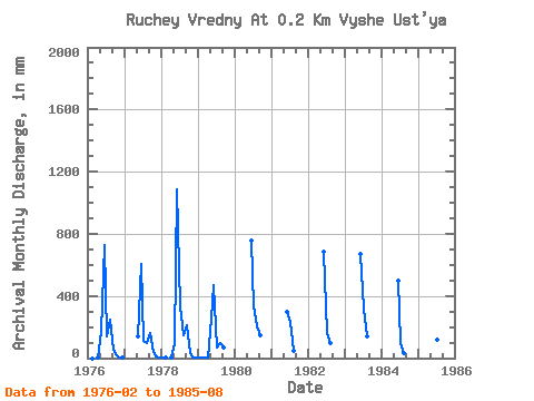
| Year | Jan | Feb | Mar | Apr | May | Jun | Jul | Aug | Sep | Oct | Nov | Dec | Annual | 1976 | 0.00 | 0.00 | 1.58 | 173.83 | 725.55 | 146.66 | 255.31 | 52.58 | 15.21 | 4.21 | 2.17 | 1977 | 0.00 | 0.00 | 0.00 | 0.00 | 141.23 | 604.62 | 114.07 | 103.21 | 162.99 | 38.02 | 11.04 | 6.52 | 1185.90 | 1978 | 2.17 | 0.49 | 0.00 | 2.10 | 97.78 | 1088.33 | 342.22 | 152.10 | 210.30 | 33.13 | 3.68 | 2.17 | 1942.36 | 1979 | 1.63 | 1.48 | 1.09 | 1.05 | 266.17 | 467.93 | 70.62 | 97.78 | 68.35 | 1980 | 757.10 | 342.22 | 211.85 | 147.21 | 1981 | 299.68 | 239.01 | 47.26 | 1982 | 683.49 | 168.39 | 97.78 | 1983 | 667.72 | 331.36 | 146.66 | 1984 | 499.47 | 103.21 | 35.85 | 1985 | 667.72 | 119.50 | 130.37 |
|---|
 Return to R-Arctic Net Home Page