|
|
|||||||||||||||||
| Point ID: 7952 | Downloads | Plots | Site Data | Code: 3588 |
|
|
|||||||||||||||||
| Download | |
|---|---|
| Site Descriptor Information | Site Time Series Data |
| Link to all available data | |
|
|
| View: | Statistics | Time Series |
| Units: | mm |
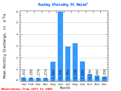
| Statistic | Jan | Feb | Mar | Apr | May | Jun | Jul | Aug | Sep | Oct | Nov | Dec | Annual |
|---|---|---|---|---|---|---|---|---|---|---|---|---|---|
| Mean | 0.30 | 0.29 | 0.27 | 0.27 | 1.66 | 5.93 | 2.95 | 3.24 | 1.68 | 0.59 | 0.48 | 0.40 | 1.53 |
| Standard Deviation | 0.04 | 0.04 | 0.04 | 0.03 | 0.63 | 2.50 | 0.36 | 1.15 | 0.55 | 0.06 | 0.07 | 0.06 | 0.16 |
| Min | 0.25 | 0.23 | 0.21 | 0.23 | 0.99 | 2.01 | 2.61 | 1.56 | 1.14 | 0.53 | 0.41 | 0.33 | 1.35 |
| Max | 0.33 | 0.32 | 0.31 | 0.29 | 2.54 | 8.99 | 3.50 | 4.51 | 2.43 | 0.65 | 0.56 | 0.48 | 1.67 |
| Coefficient of Variation | 0.13 | 0.12 | 0.14 | 0.09 | 0.38 | 0.42 | 0.12 | 0.35 | 0.33 | 0.09 | 0.15 | 0.16 | 0.10 |
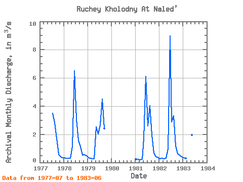
| Year | Jan | Feb | Mar | Apr | May | Jun | Jul | Aug | Sep | Oct | Nov | Dec | Annual | 1977 | 3.50 | 2.80 | 1.71 | 0.56 | 0.43 | 0.33 | 1978 | 0.33 | 0.31 | 0.30 | 0.29 | 1.13 | 6.50 | 3.08 | 1.56 | 1.14 | 0.53 | 0.56 | 0.48 | 1.35 | 1979 | 0.33 | 0.32 | 0.27 | 0.28 | 2.54 | 2.01 | 2.68 | 4.51 | 2.43 | 1981 | 0.25 | 0.23 | 0.21 | 0.23 | 1.69 | 6.10 | 2.61 | 4.02 | 1.97 | 0.65 | 0.41 | 0.38 | 1.56 | 1982 | 0.27 | 0.29 | 0.28 | 0.29 | 0.99 | 8.99 | 2.90 | 3.30 | 1.15 | 0.62 | 0.52 | 0.40 | 1.67 | 1983 | 0.33 | 0.29 | 0.31 | 0.28 | 1.97 | 6.06 |
|---|
 Return to R-Arctic Net Home Page