|
|
|||||||||||||||||
| Point ID: 7952 | Downloads | Plots | Site Data | Code: 3588 |
|
|
|||||||||||||||||
| Download | |
|---|---|
| Site Descriptor Information | Site Time Series Data |
| Link to all available data | |
|
|
| View: | Statistics | Time Series |
| Units: | m3/s |
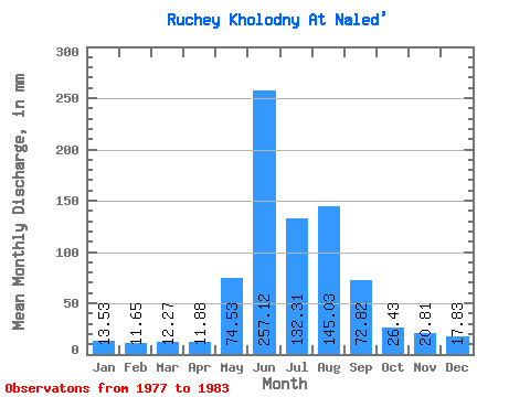
| Statistic | Jan | Feb | Mar | Apr | May | Jun | Jul | Aug | Sep | Oct | Nov | Dec | Annual |
|---|---|---|---|---|---|---|---|---|---|---|---|---|---|
| Mean | 13.52 | 11.75 | 12.27 | 11.88 | 74.52 | 257.12 | 132.29 | 145.01 | 72.82 | 26.42 | 20.80 | 17.80 | 805.71 |
| Standard Deviation | 1.75 | 1.43 | 1.75 | 1.09 | 28.33 | 108.58 | 16.00 | 51.26 | 23.94 | 2.45 | 3.11 | 2.79 | 84.94 |
| Min | 11.20 | 9.38 | 9.40 | 9.97 | 44.34 | 87.12 | 116.88 | 69.86 | 49.41 | 23.73 | 17.77 | 14.78 | 712.91 |
| Max | 14.78 | 13.06 | 13.88 | 12.57 | 113.75 | 389.67 | 156.74 | 201.97 | 105.33 | 29.11 | 24.27 | 21.50 | 879.60 |
| Coefficient of Variation | 0.13 | 0.12 | 0.14 | 0.09 | 0.38 | 0.42 | 0.12 | 0.35 | 0.33 | 0.09 | 0.15 | 0.16 | 0.10 |
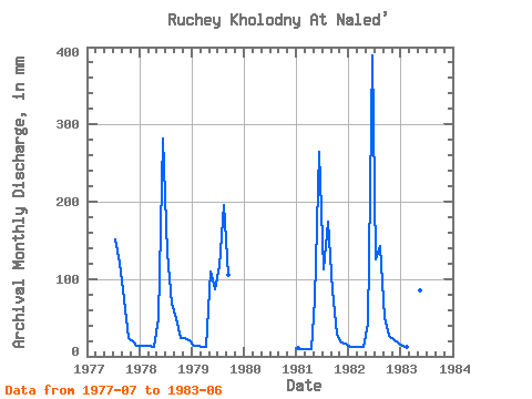
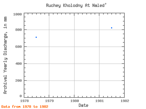
| Year | Jan | Feb | Mar | Apr | May | Jun | Jul | Aug | Sep | Oct | Nov | Dec | Annual | 1977 | 156.74 | 125.39 | 74.12 | 25.08 | 18.64 | 14.78 | 1978 | 14.78 | 12.65 | 13.44 | 12.57 | 50.60 | 281.74 | 137.93 | 69.86 | 49.41 | 23.73 | 24.27 | 21.50 | 712.91 | 1979 | 14.78 | 13.06 | 12.09 | 12.14 | 113.75 | 87.12 | 120.02 | 201.97 | 105.33 | 1981 | 11.20 | 9.38 | 9.40 | 9.97 | 75.68 | 264.40 | 116.88 | 180.03 | 85.39 | 29.11 | 17.77 | 17.02 | 824.62 | 1982 | 12.09 | 11.83 | 12.54 | 12.57 | 44.34 | 389.67 | 129.87 | 147.78 | 49.85 | 27.77 | 22.54 | 17.91 | 879.60 | 1983 | 14.78 | 11.83 | 13.88 | 12.14 | 88.22 | 262.67 |
|---|
 Return to R-Arctic Net Home Page