|
|
|||||||||||||||||
| Point ID: 7944 | Downloads | Plots | Site Data | Code: 3573 |
|
|
|||||||||||||||||
| Download | |
|---|---|
| Site Descriptor Information | Site Time Series Data |
| Link to all available data | |
|
|
| View: | Statistics | Time Series |
| Units: | mm |
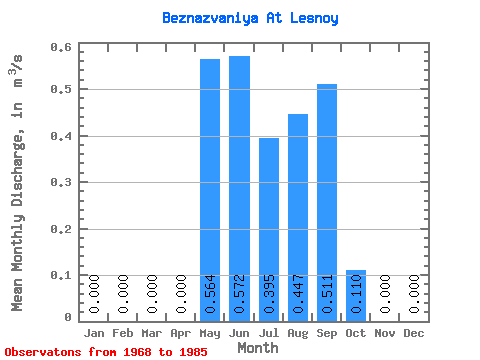
| Statistic | Jan | Feb | Mar | Apr | May | Jun | Jul | Aug | Sep | Oct | Nov | Dec | Annual |
|---|---|---|---|---|---|---|---|---|---|---|---|---|---|
| Mean | 0.00 | 0.00 | 0.00 | 0.00 | 0.56 | 0.57 | 0.40 | 0.45 | 0.51 | 0.11 | 0.00 | 0.00 | 0.22 |
| Standard Deviation | 0.00 | 0.00 | 0.00 | 0.00 | 0.25 | 0.55 | 0.31 | 0.56 | 0.68 | 0.20 | 0.00 | 0.00 | 0.15 |
| Min | 0.00 | 0.00 | 0.00 | 0.00 | 0.22 | 0.21 | 0.07 | 0.01 | 0.00 | 0.00 | 0.00 | 0.00 | 0.05 |
| Max | 0.00 | 0.00 | 0.00 | 0.00 | 0.89 | 1.63 | 0.80 | 1.49 | 1.54 | 0.51 | 0.00 | 0.00 | 0.43 |
| Coefficient of Variation | 0.45 | 0.96 | 0.79 | 1.25 | 1.33 | 1.81 | 0.68 |
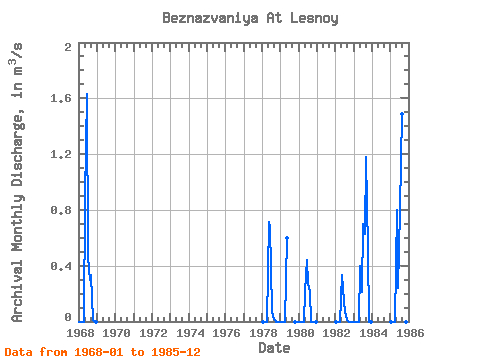
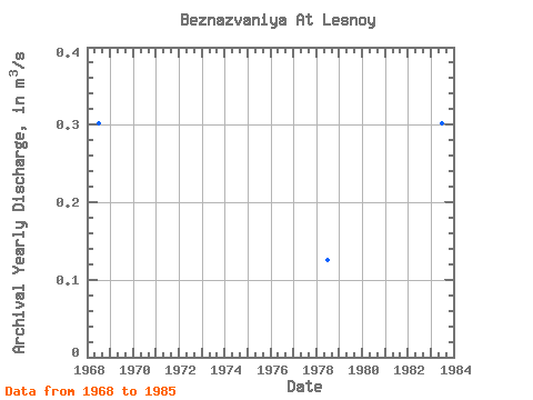
| Year | Jan | Feb | Mar | Apr | May | Jun | Jul | Aug | Sep | Oct | Nov | Dec | Annual | 1968 | 0.00 | 0.00 | 0.00 | 0.00 | 0.89 | 1.63 | 0.46 | 0.30 | 0.33 | 0.01 | 0.00 | 0.00 | 0.30 | 1978 | 0.00 | 0.00 | 0.00 | 0.00 | 0.71 | 0.68 | 0.08 | 0.03 | 0.01 | 0.00 | 0.00 | 0.00 | 0.13 | 1979 | 0.00 | 0.00 | 0.00 | 0.00 | 0.60 | 0.00 | 0.00 | 0.00 | 1980 | 0.00 | 0.00 | 0.00 | 0.00 | 0.22 | 0.44 | 0.27 | 0.22 | 0.00 | 0.00 | 0.00 | 0.00 | 0.10 | 1982 | 0.00 | 0.00 | 0.00 | 0.00 | 0.33 | 0.23 | 0.07 | 0.01 | 0.00 | 0.00 | 0.00 | 0.00 | 0.05 | 1983 | 0.00 | 0.00 | 0.00 | 0.00 | 0.40 | 0.21 | 0.70 | 0.63 | 1.18 | 0.51 | 0.00 | 0.00 | 0.30 | 1985 | 0.00 | 0.00 | 0.00 | 0.00 | 0.80 | 0.24 | 0.80 | 1.49 | 1.54 | 0.25 | 0.00 | 0.00 | 0.43 |
|---|
 Return to R-Arctic Net Home Page