|
|
|||||||||||||||||
| Point ID: 7944 | Downloads | Plots | Site Data | Code: 3573 |
|
|
|||||||||||||||||
| Download | |
|---|---|
| Site Descriptor Information | Site Time Series Data |
| Link to all available data | |
|
|
| View: | Statistics | Time Series |
| Units: | m3/s |
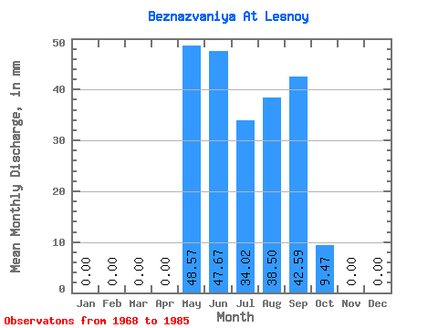
| Statistic | Jan | Feb | Mar | Apr | May | Jun | Jul | Aug | Sep | Oct | Nov | Dec | Annual |
|---|---|---|---|---|---|---|---|---|---|---|---|---|---|
| Mean | 0.00 | 0.00 | 0.00 | 0.00 | 48.59 | 47.65 | 34.04 | 38.48 | 42.59 | 9.47 | 0.00 | 0.00 | 220.84 |
| Standard Deviation | 0.00 | 0.00 | 0.00 | 0.00 | 21.80 | 45.75 | 26.87 | 48.08 | 56.60 | 17.15 | 0.00 | 0.00 | 149.32 |
| Min | 0.00 | 0.00 | 0.00 | 0.00 | 18.94 | 17.50 | 5.68 | 0.86 | 0.00 | 0.00 | 0.00 | 0.00 | 53.95 |
| Max | 0.00 | 0.00 | 0.00 | 0.00 | 76.64 | 135.85 | 68.89 | 128.30 | 128.35 | 43.92 | 0.00 | 0.00 | 432.98 |
| Coefficient of Variation | 0.45 | 0.96 | 0.79 | 1.25 | 1.33 | 1.81 | 0.68 |
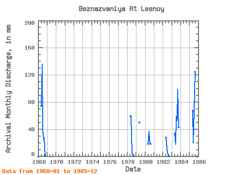
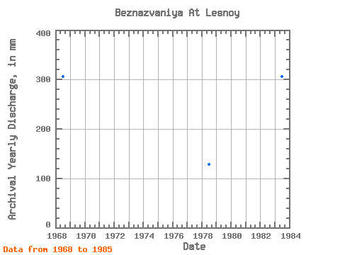
| Year | Jan | Feb | Mar | Apr | May | Jun | Jul | Aug | Sep | Oct | Nov | Dec | Annual | 1968 | 0.00 | 0.00 | 0.00 | 0.00 | 76.64 | 135.85 | 39.61 | 25.83 | 27.50 | 0.86 | 0.00 | 0.00 | 306.13 | 1978 | 0.00 | 0.00 | 0.00 | 0.00 | 61.14 | 56.67 | 6.54 | 2.67 | 1.17 | 0.00 | 0.00 | 0.00 | 127.78 | 1979 | 0.00 | 0.00 | 0.00 | 0.00 | 51.67 | 0.00 | 0.00 | 0.00 | 1980 | 0.00 | 0.00 | 0.00 | 0.00 | 18.94 | 36.67 | 23.25 | 18.94 | 0.00 | 0.00 | 0.00 | 0.00 | 97.25 | 1982 | 0.00 | 0.00 | 0.00 | 0.00 | 28.42 | 19.17 | 5.68 | 0.86 | 0.17 | 0.00 | 0.00 | 0.00 | 53.95 | 1983 | 0.00 | 0.00 | 0.00 | 0.00 | 34.44 | 17.50 | 60.28 | 54.25 | 98.35 | 43.92 | 0.00 | 0.00 | 306.97 | 1985 | 0.00 | 0.00 | 0.00 | 0.00 | 68.89 | 20.00 | 68.89 | 128.30 | 128.35 | 21.53 | 0.00 | 0.00 | 432.98 |
|---|
 Return to R-Arctic Net Home Page