|
|
|||||||||||||||||
| Point ID: 7917 | Downloads | Plots | Site Data | Code: 3469 |
|
|
|||||||||||||||||
| Download | |
|---|---|
| Site Descriptor Information | Site Time Series Data |
| Link to all available data | |
|
|
| View: | Statistics | Time Series |
| Units: | mm |
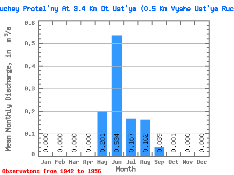
| Statistic | Jan | Feb | Mar | Apr | May | Jun | Jul | Aug | Sep | Oct | Nov | Dec | Annual |
|---|---|---|---|---|---|---|---|---|---|---|---|---|---|
| Mean | 0.00 | 0.00 | 0.00 | 0.00 | 0.20 | 0.53 | 0.17 | 0.16 | 0.04 | 0.00 | 0.00 | 0.00 | 0.09 |
| Standard Deviation | 0.00 | 0.00 | 0.00 | 0.00 | 0.14 | 0.24 | 0.09 | 0.11 | 0.04 | 0.00 | 0.00 | 0.00 | 0.02 |
| Min | 0.00 | 0.00 | 0.00 | 0.00 | 0.04 | 0.16 | 0.03 | 0.06 | 0.01 | 0.00 | 0.00 | 0.00 | 0.06 |
| Max | 0.00 | 0.00 | 0.00 | 0.00 | 0.37 | 0.77 | 0.24 | 0.31 | 0.11 | 0.00 | 0.00 | 0.00 | 0.11 |
| Coefficient of Variation | 0.69 | 0.44 | 0.51 | 0.68 | 1.07 | 1.09 | 0.25 |
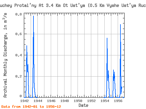
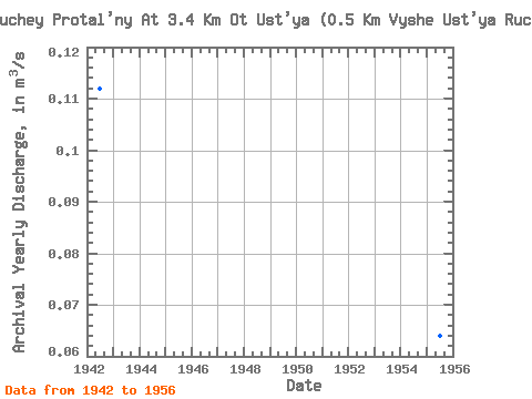
| Year | Jan | Feb | Mar | Apr | May | Jun | Jul | Aug | Sep | Oct | Nov | Dec | Annual | 1942 | 0.00 | 0.00 | 0.00 | 0.00 | 0.26 | 0.49 | 0.24 | 0.31 | 0.04 | 0.00 | 0.00 | 0.00 | 0.11 | 1943 | 0.00 | 0.00 | 0.00 | 0.00 | 0.37 | 0.77 | 0.16 | 0.06 | 0.01 | 0.00 | 0.00 | 0.00 | 0.11 | 1954 | 0.00 | 0.00 | 0.00 | 0.00 | 0.08 | 0.56 | 0.16 | 0.25 | 0.11 | 0.00 | 0.00 | 0.00 | 0.10 | 1955 | 0.00 | 0.00 | 0.00 | 0.00 | 0.26 | 0.16 | 0.24 | 0.10 | 0.02 | 0.00 | 0.00 | 0.00 | 0.06 | 1956 | 0.00 | 0.00 | 0.00 | 0.00 | 0.04 | 0.69 | 0.03 | 0.10 | 0.01 | 0.00 | 0.00 | 0.00 | 0.07 |
|---|
 Return to R-Arctic Net Home Page