|
|
|||||||||||||||||
| Point ID: 7917 | Downloads | Plots | Site Data | Code: 3469 |
|
|
|||||||||||||||||
| Download | |
|---|---|
| Site Descriptor Information | Site Time Series Data |
| Link to all available data | |
|
|
| View: | Statistics | Time Series |
| Units: | m3/s |
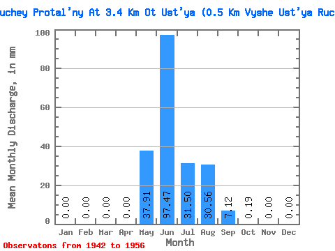
| Statistic | Jan | Feb | Mar | Apr | May | Jun | Jul | Aug | Sep | Oct | Nov | Dec | Annual |
|---|---|---|---|---|---|---|---|---|---|---|---|---|---|
| Mean | 0.00 | 0.00 | 0.00 | 0.00 | 37.89 | 97.47 | 31.42 | 30.63 | 7.16 | 0.23 | 0.00 | 0.00 | 204.53 |
| Standard Deviation | 0.00 | 0.00 | 0.00 | 0.00 | 26.29 | 43.05 | 15.98 | 20.86 | 7.65 | 0.25 | 0.00 | 0.00 | 50.52 |
| Min | 0.00 | 0.00 | 0.00 | 0.00 | 6.79 | 29.21 | 6.22 | 10.94 | 2.01 | 0.00 | 0.00 | 0.00 | 143.35 |
| Max | 0.00 | 0.00 | 0.00 | 0.00 | 69.78 | 140.55 | 45.26 | 58.46 | 20.08 | 0.57 | 0.00 | 0.00 | 254.29 |
| Coefficient of Variation | 0.69 | 0.44 | 0.51 | 0.68 | 1.07 | 1.09 | 0.25 |
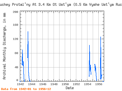
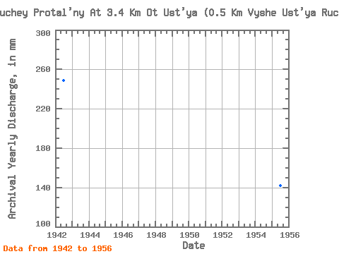
| Year | Jan | Feb | Mar | Apr | May | Jun | Jul | Aug | Sep | Oct | Nov | Dec | Annual | 1942 | 0.00 | 0.00 | 0.00 | 0.00 | 49.03 | 89.44 | 45.26 | 58.46 | 8.21 | 0.19 | 0.00 | 0.00 | 249.29 | 1943 | 0.00 | 0.00 | 0.00 | 0.00 | 69.78 | 140.55 | 30.18 | 10.94 | 2.37 | 0.38 | 0.00 | 0.00 | 254.29 | 1954 | 0.00 | 0.00 | 0.00 | 0.00 | 14.82 | 102.22 | 30.18 | 47.15 | 20.08 | 0.00 | 0.00 | 0.00 | 214.59 | 1955 | 0.00 | 0.00 | 0.00 | 0.00 | 49.03 | 29.21 | 45.26 | 18.29 | 3.10 | 0.00 | 0.00 | 0.00 | 143.35 | 1956 | 0.00 | 0.00 | 0.00 | 0.00 | 6.79 | 125.95 | 6.22 | 18.29 | 2.01 | 0.57 | 0.00 | 0.00 | 161.13 |
|---|
 Return to R-Arctic Net Home Page