|
|
|||||||||||||||||
| Point ID: 7911 | Downloads | Plots | Site Data | Code: 3434 |
|
|
|||||||||||||||||
| Download | |
|---|---|
| Site Descriptor Information | Site Time Series Data |
| Link to all available data | |
|
|
| View: | Statistics | Time Series |
| Units: | mm |
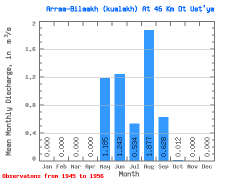
| Statistic | Jan | Feb | Mar | Apr | May | Jun | Jul | Aug | Sep | Oct | Nov | Dec | Annual |
|---|---|---|---|---|---|---|---|---|---|---|---|---|---|
| Mean | 0.00 | 0.00 | 0.00 | 0.00 | 1.19 | 1.24 | 0.53 | 1.88 | 0.63 | 0.01 | 0.00 | 0.00 | 0.46 |
| Standard Deviation | 0.00 | 0.00 | 0.00 | 0.00 | 1.30 | 1.15 | 0.42 | 3.18 | 0.69 | 0.02 | 0.00 | 0.00 | 0.41 |
| Min | 0.00 | 0.00 | 0.00 | 0.00 | 0.08 | 0.14 | 0.05 | 0.11 | 0.03 | 0.00 | 0.00 | 0.00 | 0.13 |
| Max | 0.00 | 0.00 | 0.00 | 0.00 | 4.23 | 3.44 | 1.23 | 9.80 | 1.72 | 0.05 | 0.00 | 0.00 | 1.32 |
| Coefficient of Variation | 1.10 | 0.93 | 0.78 | 1.69 | 1.10 | 1.41 | 0.90 |
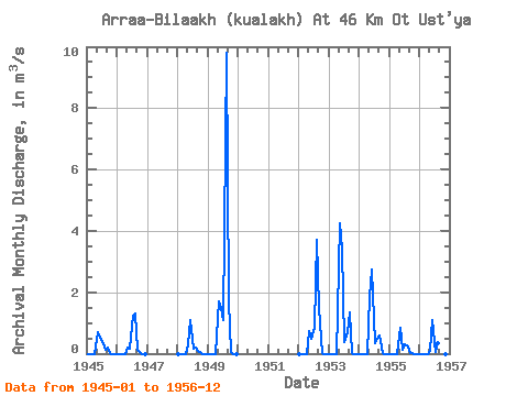
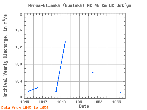
| Year | Jan | Feb | Mar | Apr | May | Jun | Jul | Aug | Sep | Oct | Nov | Dec | Annual | 1945 | 0.00 | 0.00 | 0.00 | 0.00 | 0.69 | 0.52 | 0.41 | 0.11 | 0.20 | 0.01 | 0.00 | 0.00 | 0.16 | 1946 | 0.00 | 0.00 | 0.00 | 0.00 | 0.18 | 0.16 | 1.23 | 1.30 | 0.12 | 0.01 | 0.00 | 0.00 | 0.25 | 1948 | 0.00 | 0.00 | 0.00 | 0.00 | 0.32 | 1.11 | 0.17 | 0.20 | 0.10 | 0.01 | 0.00 | 0.00 | 0.16 | 1949 | 0.00 | 0.00 | 0.00 | 0.00 | 1.70 | 1.49 | 1.10 | 9.80 | 1.72 | 0.05 | 0.00 | 0.00 | 1.32 | 1952 | 0.00 | 0.00 | 0.00 | 0.00 | 0.75 | 0.50 | 0.84 | 3.70 | 1.49 | 0.03 | 0.00 | 0.00 | 0.61 | 1953 | 0.00 | 0.00 | 0.00 | 0.00 | 4.23 | 3.44 | 0.38 | 0.71 | 1.34 | 0.01 | 0.00 | 0.00 | 0.84 | 1954 | 0.00 | 0.00 | 0.00 | 0.00 | 1.85 | 2.74 | 0.34 | 0.49 | 0.59 | 0.00 | 0.00 | 0.00 | 0.50 | 1955 | 0.00 | 0.00 | 0.00 | 0.00 | 0.86 | 0.14 | 0.29 | 0.24 | 0.03 | 0.00 | 0.00 | 0.00 | 0.13 | 1956 | 0.00 | 0.00 | 0.00 | 0.00 | 0.08 | 1.09 | 0.05 | 0.34 | 0.07 | 0.00 | 0.00 | 0.00 | 0.14 |
|---|
 Return to R-Arctic Net Home Page