|
|
|||||||||||||||||
| Point ID: 7906 | Downloads | Plots | Site Data | Code: 3415 |
|
|
|||||||||||||||||
| Download | |
|---|---|
| Site Descriptor Information | Site Time Series Data |
| Link to all available data | |
|
|
| View: | Statistics | Time Series |
| Units: | mm |
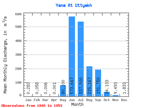
| Statistic | Jan | Feb | Mar | Apr | May | Jun | Jul | Aug | Sep | Oct | Nov | Dec | Annual |
|---|---|---|---|---|---|---|---|---|---|---|---|---|---|
| Mean | 0.28 | 0.06 | 0.01 | 0.00 | 80.10 | 573.67 | 537.50 | 215.17 | 191.75 | 34.13 | 9.49 | 1.83 | 137.00 |
| Standard Deviation | 0.11 | 0.07 | 0.01 | 0.00 | 65.57 | 212.90 | 252.84 | 60.19 | 173.07 | 15.19 | 9.53 | 1.58 | 37.84 |
| Min | 0.17 | 0.00 | 0.00 | 0.00 | 13.20 | 363.00 | 208.00 | 110.00 | 56.00 | 18.70 | 2.85 | 0.61 | 86.74 |
| Max | 0.47 | 0.20 | 0.03 | 0.01 | 197.00 | 968.00 | 912.00 | 284.00 | 508.00 | 60.40 | 27.60 | 4.61 | 186.53 |
| Coefficient of Variation | 0.40 | 1.27 | 1.99 | 1.75 | 0.82 | 0.37 | 0.47 | 0.28 | 0.90 | 0.45 | 1.00 | 0.86 | 0.28 |
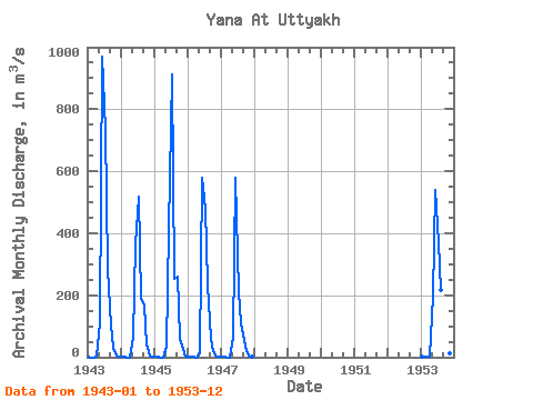
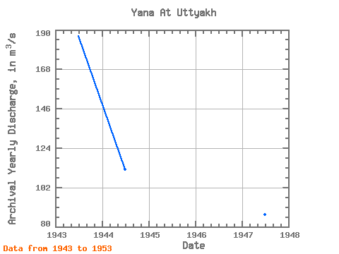
| Year | Jan | Feb | Mar | Apr | May | Jun | Jul | Aug | Sep | Oct | Nov | Dec | Annual | 1943 | 0.37 | 0.00 | 0.00 | 0.00 | 108.00 | 968.00 | 736.00 | 284.00 | 102.00 | 31.60 | 7.09 | 1.29 | 186.53 | 1944 | 0.17 | 0.03 | 0.00 | 0.00 | 62.00 | 363.00 | 518.00 | 193.00 | 165.00 | 39.70 | 3.78 | 0.74 | 112.12 | 1945 | 0.24 | 0.01 | 0.00 | 0.00 | 35.00 | 414.00 | 912.00 | 253.00 | 261.00 | 60.40 | 27.60 | 2.84 | 163.84 | 1946 | 0.21 | 0.07 | 0.01 | 0.00 | 13.20 | 579.00 | 480.00 | 235.00 | 58.50 | 20.40 | 3.44 | 0.91 | 115.89 | 1947 | 0.24 | 0.03 | 0.00 | 0.00 | 65.40 | 579.00 | 208.00 | 110.00 | 56.00 | 18.70 | 2.85 | 0.61 | 86.74 | 1953 | 0.47 | 0.20 | 0.03 | 0.01 | 197.00 | 539.00 | 371.00 | 216.00 | 508.00 | 34.00 | 12.20 | 4.61 | 156.88 |
|---|
 Return to R-Arctic Net Home Page