|
|
|||||||||||||||||
| Point ID: 7906 | Downloads | Plots | Site Data | Code: 3415 |
|
|
|||||||||||||||||
| Download | |
|---|---|
| Site Descriptor Information | Site Time Series Data |
| Link to all available data | |
|
|
| View: | Statistics | Time Series |
| Units: | m3/s |
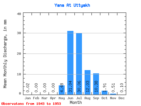
| Statistic | Jan | Feb | Mar | Apr | May | Jun | Jul | Aug | Sep | Oct | Nov | Dec | Annual |
|---|---|---|---|---|---|---|---|---|---|---|---|---|---|
| Mean | 0.02 | 0.00 | 0.00 | 0.00 | 4.48 | 31.04 | 30.05 | 12.03 | 10.38 | 1.91 | 0.51 | 0.10 | 90.27 |
| Standard Deviation | 0.01 | 0.00 | 0.00 | 0.00 | 3.67 | 11.52 | 14.14 | 3.37 | 9.37 | 0.85 | 0.52 | 0.09 | 24.93 |
| Min | 0.01 | 0.00 | 0.00 | 0.00 | 0.74 | 19.64 | 11.63 | 6.15 | 3.03 | 1.04 | 0.15 | 0.03 | 57.15 |
| Max | 0.03 | 0.01 | 0.00 | 0.00 | 11.01 | 52.38 | 50.99 | 15.88 | 27.49 | 3.38 | 1.49 | 0.26 | 122.90 |
| Coefficient of Variation | 0.40 | 1.27 | 1.99 | 1.75 | 0.82 | 0.37 | 0.47 | 0.28 | 0.90 | 0.45 | 1.00 | 0.86 | 0.28 |
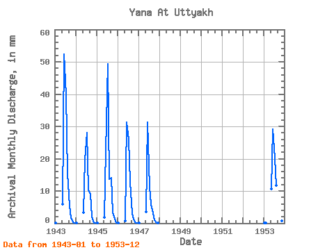
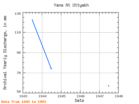
| Year | Jan | Feb | Mar | Apr | May | Jun | Jul | Aug | Sep | Oct | Nov | Dec | Annual | 1943 | 0.02 | 0.00 | 0.00 | 0.00 | 6.04 | 52.38 | 41.15 | 15.88 | 5.52 | 1.77 | 0.38 | 0.07 | 122.90 | 1944 | 0.01 | 0.00 | 0.00 | 0.00 | 3.47 | 19.64 | 28.96 | 10.79 | 8.93 | 2.22 | 0.20 | 0.04 | 73.87 | 1945 | 0.01 | 0.00 | 0.00 | 0.00 | 1.96 | 22.40 | 50.99 | 14.14 | 14.12 | 3.38 | 1.49 | 0.16 | 107.95 | 1946 | 0.01 | 0.00 | 0.00 | 0.00 | 0.74 | 31.33 | 26.84 | 13.14 | 3.17 | 1.14 | 0.19 | 0.05 | 76.36 | 1947 | 0.01 | 0.00 | 0.00 | 0.00 | 3.66 | 31.33 | 11.63 | 6.15 | 3.03 | 1.04 | 0.15 | 0.03 | 57.15 | 1953 | 0.03 | 0.01 | 0.00 | 0.00 | 11.01 | 29.17 | 20.74 | 12.08 | 27.49 | 1.90 | 0.66 | 0.26 | 103.36 |
|---|
 Return to R-Arctic Net Home Page