|
|
|||||||||||||||||
| Point ID: 7890 | Downloads | Plots | Site Data | Code: 3375 |
|
|
|||||||||||||||||
| Download | |
|---|---|
| Site Descriptor Information | Site Time Series Data |
| Link to all available data | |
|
|
| View: | Statistics | Time Series |
| Units: | mm |
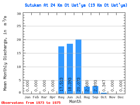
| Statistic | Jan | Feb | Mar | Apr | May | Jun | Jul | Aug | Sep | Oct | Nov | Dec | Annual |
|---|---|---|---|---|---|---|---|---|---|---|---|---|---|
| Mean | 0.00 | 0.00 | 0.00 | 0.00 | 17.51 | 18.39 | 20.07 | 2.68 | 2.89 | 0.35 | 0.00 | 0.00 | 5.16 |
| Standard Deviation | 0.00 | 0.00 | 0.00 | 0.00 | 10.71 | 11.06 | 18.04 | 3.48 | 1.92 | 0.15 | 0.00 | 0.00 | 1.57 |
| Min | 0.00 | 0.00 | 0.00 | 0.00 | 5.54 | 9.58 | 1.02 | 0.64 | 1.33 | 0.17 | 0.00 | 0.00 | 3.36 |
| Max | 0.00 | 0.00 | 0.00 | 0.00 | 26.20 | 30.80 | 36.90 | 6.70 | 5.03 | 0.46 | 0.00 | 0.00 | 6.22 |
| Coefficient of Variation | 0.61 | 0.60 | 0.90 | 1.30 | 0.66 | 0.45 | 1.73 | 0.30 |
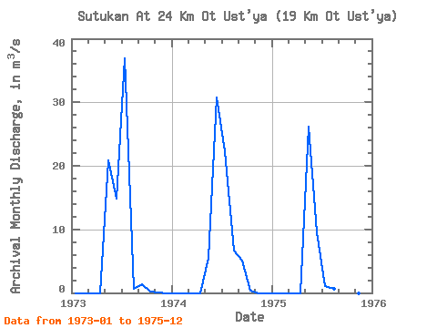
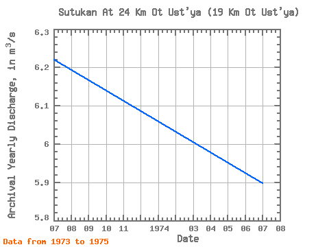
| Year | Jan | Feb | Mar | Apr | May | Jun | Jul | Aug | Sep | Oct | Nov | Dec | Annual | 1973 | 0.00 | 0.00 | 0.00 | 0.00 | 20.80 | 14.80 | 36.90 | 0.64 | 1.33 | 0.17 | 0.00 | 0.00 | 6.22 | 1974 | 0.00 | 0.00 | 0.00 | 0.00 | 5.54 | 30.80 | 22.30 | 6.70 | 5.03 | 0.41 | 0.00 | 0.00 | 5.90 | 1975 | 0.00 | 0.00 | 0.00 | 0.00 | 26.20 | 9.58 | 1.02 | 0.70 | 2.32 | 0.46 | 0.00 | 0.00 | 3.36 |
|---|
 Return to R-Arctic Net Home Page