|
|
|||||||||||||||||
| Point ID: 7890 | Downloads | Plots | Site Data | Code: 3375 |
|
|
|||||||||||||||||
| Download | |
|---|---|
| Site Descriptor Information | Site Time Series Data |
| Link to all available data | |
|
|
| View: | Statistics | Time Series |
| Units: | m3/s |
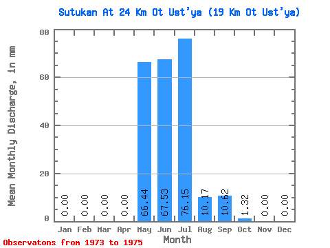
| Statistic | Jan | Feb | Mar | Apr | May | Jun | Jul | Aug | Sep | Oct | Nov | Dec | Annual |
|---|---|---|---|---|---|---|---|---|---|---|---|---|---|
| Mean | 0.00 | 0.00 | 0.00 | 0.00 | 66.43 | 67.53 | 76.14 | 10.17 | 10.62 | 1.31 | 0.00 | 0.00 | 230.59 |
| Standard Deviation | 0.00 | 0.00 | 0.00 | 0.00 | 40.64 | 40.59 | 68.44 | 13.21 | 7.03 | 0.59 | 0.00 | 0.00 | 70.12 |
| Min | 0.00 | 0.00 | 0.00 | 0.00 | 21.01 | 35.17 | 3.87 | 2.43 | 4.88 | 0.65 | 0.00 | 0.00 | 150.05 |
| Max | 0.00 | 0.00 | 0.00 | 0.00 | 99.38 | 113.08 | 139.97 | 25.41 | 18.47 | 1.75 | 0.00 | 0.00 | 278.05 |
| Coefficient of Variation | 0.61 | 0.60 | 0.90 | 1.30 | 0.66 | 0.45 | 1.73 | 0.30 |
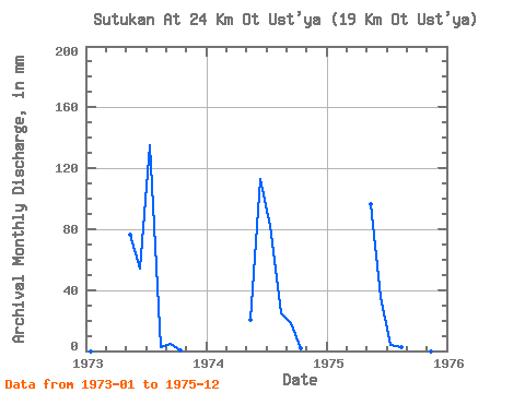
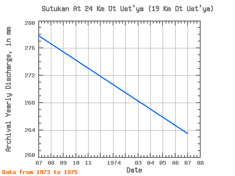
| Year | Jan | Feb | Mar | Apr | May | Jun | Jul | Aug | Sep | Oct | Nov | Dec | Annual | 1973 | 0.00 | 0.00 | 0.00 | 0.00 | 78.90 | 54.34 | 139.97 | 2.43 | 4.88 | 0.65 | 0.00 | 0.00 | 278.05 | 1974 | 0.00 | 0.00 | 0.00 | 0.00 | 21.01 | 113.08 | 84.59 | 25.41 | 18.47 | 1.56 | 0.00 | 0.00 | 263.67 | 1975 | 0.00 | 0.00 | 0.00 | 0.00 | 99.38 | 35.17 | 3.87 | 2.66 | 8.52 | 1.75 | 0.00 | 0.00 | 150.05 |
|---|
 Return to R-Arctic Net Home Page