|
|
|||||||||||||||||
| Point ID: 7888 | Downloads | Plots | Site Data | Code: 3372 |
|
|
|||||||||||||||||
| Download | |
|---|---|
| Site Descriptor Information | Site Time Series Data |
| Link to all available data | |
|
|
| View: | Statistics | Time Series |
| Units: | mm |
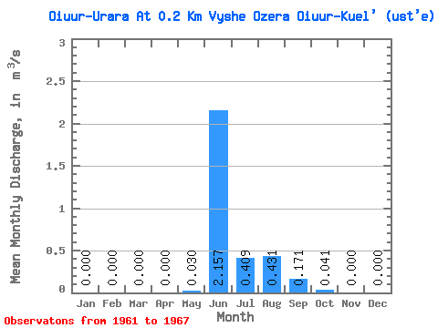
| Statistic | Jan | Feb | Mar | Apr | May | Jun | Jul | Aug | Sep | Oct | Nov | Dec | Annual |
|---|---|---|---|---|---|---|---|---|---|---|---|---|---|
| Mean | 0.00 | 0.00 | 0.00 | 0.00 | 0.03 | 2.16 | 0.41 | 0.43 | 0.17 | 0.04 | 0.00 | 0.00 | 0.27 |
| Standard Deviation | 0.00 | 0.00 | 0.00 | 0.00 | 0.06 | 1.33 | 0.53 | 0.83 | 0.13 | 0.04 | 0.00 | 0.00 | 0.20 |
| Min | 0.00 | 0.00 | 0.00 | 0.00 | 0.00 | 0.35 | 0.03 | 0.01 | 0.01 | 0.00 | 0.00 | 0.00 | 0.05 |
| Max | 0.00 | 0.00 | 0.00 | 0.00 | 0.12 | 3.22 | 1.17 | 1.67 | 0.28 | 0.09 | 0.00 | 0.00 | 0.53 |
| Coefficient of Variation | 2.00 | 0.62 | 1.29 | 1.92 | 0.78 | 1.02 | 2.00 | 0.74 |
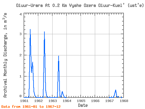
| Year | Jan | Feb | Mar | Apr | May | Jun | Jul | Aug | Sep | Oct | Nov | Dec | Annual | 1961 | 0.00 | 0.00 | 0.00 | 0.00 | 0.00 | 3.22 | 1.17 | 1.67 | 0.28 | 0.06 | 0.00 | 0.00 | 0.53 | 1962 | 0.00 | 0.00 | 0.00 | 0.00 | 0.00 | 3.10 | 0.35 | 0.02 | 0.01 | 0.00 | 0.00 | 0.00 | 0.29 | 1963 | 0.00 | 0.00 | 0.00 | 0.00 | 0.00 | 1.96 | 0.09 | 0.01 | 0.28 | 0.09 | 0.00 | 0.00 | 0.20 | 1967 | 0.00 | 0.00 | 0.00 | 0.00 | 0.12 | 0.35 | 0.03 | 0.02 | 0.12 | 0.01 | 0.00 | 0.00 | 0.05 |
|---|
 Return to R-Arctic Net Home Page