|
|
|||||||||||||||||
| Point ID: 7888 | Downloads | Plots | Site Data | Code: 3372 |
|
|
|||||||||||||||||
| Download | |
|---|---|
| Site Descriptor Information | Site Time Series Data |
| Link to all available data | |
|
|
| View: | Statistics | Time Series |
| Units: | m3/s |
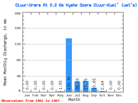
| Statistic | Jan | Feb | Mar | Apr | May | Jun | Jul | Aug | Sep | Oct | Nov | Dec | Annual |
|---|---|---|---|---|---|---|---|---|---|---|---|---|---|
| Mean | 0.00 | 0.00 | 0.00 | 0.00 | 1.93 | 134.43 | 26.33 | 27.73 | 10.69 | 2.64 | 0.02 | 0.00 | 204.84 |
| Standard Deviation | 0.00 | 0.00 | 0.00 | 0.00 | 3.86 | 83.00 | 33.88 | 53.19 | 8.33 | 2.71 | 0.03 | 0.00 | 152.24 |
| Min | 0.00 | 0.00 | 0.00 | 0.00 | 0.00 | 21.81 | 1.61 | 0.77 | 0.37 | 0.00 | 0.00 | 0.00 | 41.03 |
| Max | 0.00 | 0.00 | 0.00 | 0.00 | 7.72 | 200.63 | 75.32 | 107.51 | 17.45 | 5.92 | 0.06 | 0.00 | 404.55 |
| Coefficient of Variation | 2.00 | 0.62 | 1.29 | 1.92 | 0.78 | 1.02 | 2.00 | 0.74 |
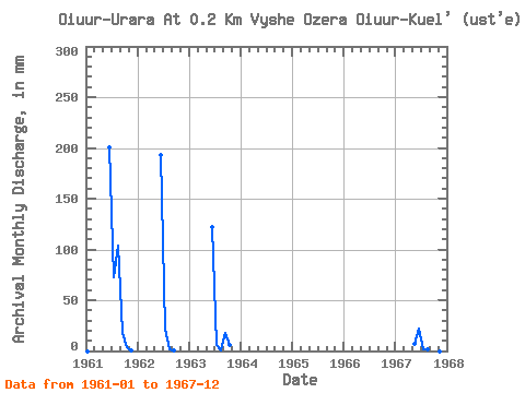
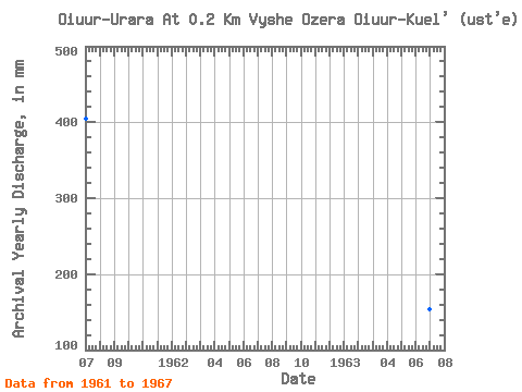
| Year | Jan | Feb | Mar | Apr | May | Jun | Jul | Aug | Sep | Oct | Nov | Dec | Annual | 1961 | 0.00 | 0.00 | 0.00 | 0.00 | 0.00 | 200.63 | 75.32 | 107.51 | 17.45 | 3.73 | 0.06 | 0.00 | 404.55 | 1962 | 0.00 | 0.00 | 0.00 | 0.00 | 0.00 | 193.15 | 22.53 | 1.35 | 0.37 | 0.00 | 0.00 | 0.00 | 219.82 | 1963 | 0.00 | 0.00 | 0.00 | 0.00 | 0.00 | 122.12 | 5.86 | 0.77 | 17.45 | 5.92 | 0.00 | 0.00 | 153.94 | 1967 | 0.00 | 0.00 | 0.00 | 0.00 | 7.72 | 21.81 | 1.61 | 1.29 | 7.48 | 0.90 | 0.00 | 0.00 | 41.03 |
|---|
 Return to R-Arctic Net Home Page