|
|
|||||||||||||||||
| Point ID: 7886 | Downloads | Plots | Site Data | Code: 3368 |
|
|
|||||||||||||||||
| Download | |
|---|---|
| Site Descriptor Information | Site Time Series Data |
| Link to all available data | |
|
|
| View: | Statistics | Time Series |
| Units: | mm |
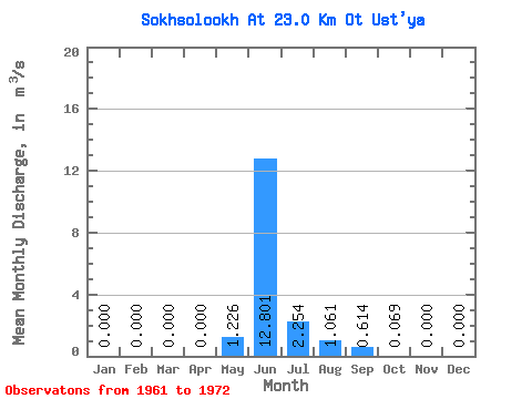
| Statistic | Jan | Feb | Mar | Apr | May | Jun | Jul | Aug | Sep | Oct | Nov | Dec | Annual |
|---|---|---|---|---|---|---|---|---|---|---|---|---|---|
| Mean | 0.00 | 0.00 | 0.00 | 0.00 | 1.23 | 12.80 | 2.25 | 1.06 | 0.61 | 0.07 | 0.00 | 0.00 | 1.50 |
| Standard Deviation | 0.00 | 0.00 | 0.00 | 0.00 | 1.94 | 4.56 | 1.27 | 1.73 | 0.54 | 0.08 | 0.00 | 0.00 | 0.42 |
| Min | 0.00 | 0.00 | 0.00 | 0.00 | 0.04 | 4.71 | 0.30 | 0.00 | 0.04 | 0.00 | 0.00 | 0.00 | 1.02 |
| Max | 0.00 | 0.00 | 0.00 | 0.00 | 5.44 | 18.40 | 3.13 | 4.27 | 1.37 | 0.22 | 0.00 | 0.00 | 1.94 |
| Coefficient of Variation | 1.58 | 0.36 | 0.56 | 1.63 | 0.87 | 1.18 | 0.28 |
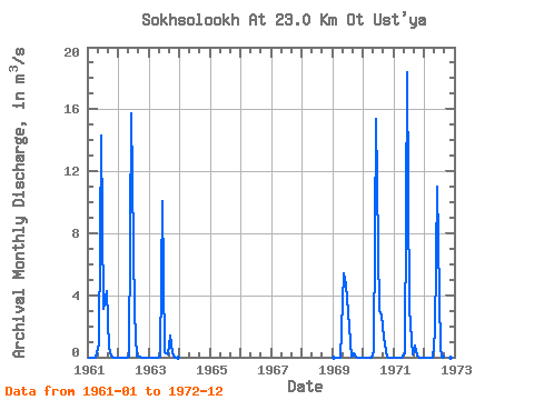
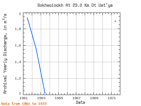
| Year | Jan | Feb | Mar | Apr | May | Jun | Jul | Aug | Sep | Oct | Nov | Dec | Annual | 1961 | 0.00 | 0.00 | 0.00 | 0.00 | 0.84 | 14.30 | 3.13 | 4.27 | 0.61 | 0.12 | 0.00 | 0.00 | 1.94 | 1962 | 0.00 | 0.00 | 0.00 | 0.00 | 0.04 | 15.70 | 2.82 | 0.07 | 0.05 | 0.00 | 0.00 | 0.00 | 1.56 | 1963 | 0.00 | 0.00 | 0.00 | 0.00 | 0.07 | 10.10 | 0.30 | 0.17 | 1.37 | 0.22 | 0.00 | 0.00 | 1.02 | 1969 | 0.00 | 0.00 | 0.00 | 0.00 | 5.44 | 4.71 | 2.92 | 0.02 | 0.28 | 0.00 | 0.00 | 0.00 | 1.11 | 1970 | 0.00 | 0.00 | 0.00 | 0.00 | 0.37 | 15.40 | 3.00 | 2.73 | 1.23 | 0.04 | 0.00 | 0.00 | 1.90 | 1971 | 0.00 | 0.00 | 0.00 | 0.00 | 0.24 | 18.40 | 3.11 | 0.17 | 0.72 | 0.09 | 0.00 | 0.00 | 1.89 | 1972 | 0.00 | 0.00 | 0.00 | 0.00 | 1.58 | 11.00 | 0.50 | 0.00 | 0.04 | 0.01 | 0.00 | 0.00 | 1.09 |
|---|
 Return to R-Arctic Net Home Page